Borken geodata
Borken (Hesse) is a populated place; located in Germany in Europe/Berlin (GMT+2) time zone. With population of 13,531 people, there are 1184 cities with bigger population in this country. Compared to other cities in Germany, 58.8% of cities are located further ↓South; 60.9% of cities are located further →East and 50.2% of cities have higher elevation than Borken. Note1
Administrative division(s):
- Level 1: Hesse
- Level 2: Regierungsbezirk Kassel
- Level 3: Schwalm-Eder-Kreis
- Level 4: Borken (Hessen)


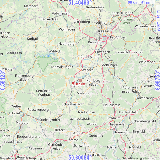
Borken GPS coordinates[2]
51° 2' 42.036" North, 9° 17' 3.84" East
| Map corner | latitude | longitude |
|---|---|---|
| Upper-left | 51.48496°, | 8.58128° |
| Center: | 51.04501°, | 9.2844° |
| Lower-right: | 50.60084°, | 9.98753° |
| Map W x H: | 98.3×98.3 km | = 61.1×61.1mi |
| max Lat: | 55.01917° ⇑41.2% North |
| Borken: | 51.04501° |
| min Lat: | ⇓58.8% South 47.40724° |
| min Long | Borken | max Long |
| 5.92978° | 9.2844° | 14.98853° |
| W 39.1%⇐ | ⇒60.9% E |
Elevation
Elevation of Borken is 224 m = 735 ft, and this is 25.1 m = 82 ft below average elevation for this country.
| Max E: |
1256 m = 4121 ft | 50.2% |
| Avg. | 249.1 m = 817 ft | |
| Borken | 224 m = 735 ft | |
Min E: |
-5 m = -16 ft | 49.8% |
See also: Germany elevation on elevation.city.
Geographical zone
Borken is located in North temperate zone (between Tropic of Cancer and the Arctic Circle). Distance of this North polar circle is 1725.5 km =1072.2 mi to North.| Distance of | km | miles | from Borken |
|---|---|---|---|
| North Pole | 4331.4 | 2691.4 | to North |
| Arctic Circle | 1725.5 | 1072.2 | to North |
| Tropic Cancer | 3069.8 | 1907.5 | to South |
| Equator | 5675.7 | 3526.7 | to South |


Nearby cities:
15 places around Borken: (largest is in red/bold)
• Bad Wildungen
13.9 km =8.6 mi,  306°
306°
• Felsberg
14.1 km =8.8 mi,  42°
42°
• Frielendorf
8.7 km =5.4 mi,  162°
162°
• Fritzlar
9.7 km =6 mi,  356°
356°
• Gilserberg
18.5 km =11.5 mi,  235°
235°
• Gudensberg
15.8 km =9.8 mi,  21°
21°
• Homberg
8.4 km =5.2 mi,  101°
101°
• Jesberg
10.6 km =6.6 mi, 241°
• Malsfeld
18.5 km =11.5 mi,  74°
74°
• Neuental
6.9 km =4.3 mi,  223°
223°
• Reinhardshausen
16.4 km =10.2 mi,  296°
296°
• Riebelsdorf
18.6 km =11.6 mi,  174°
174°
• Schwalmstadt
13.3 km =8.3 mi,  200°
200°
• Seigertshausen
15.7 km =9.8 mi, 160°
• Wabern
7.6 km =4.7 mi, 36°
Sources, notices
• [Note1] Compared only with cities in Germany existing in our database
• [Src1] Map data: © OpenStreetMap contributors (CC-BY-SA)
• [Src2] Other city data from geonames.org with taken over terms of usage.
• [Src3] Geographical zone / Annual Mean Temperature by Robert A. Rohde @ Wikipedia
