Bad Wildungen geodata
Bad Wildungen (Hesse) is a populated place; located in Germany in Europe/Berlin (GMT+2) time zone. With population of 18,037 people, there are 877 cities with bigger population in this country. Compared to other cities in Germany, 60.2% of cities are located further ↓South; 63.6% of cities are located further →East and 57.6% of cities have lower elevation than Bad Wildungen. Note1
Administrative division(s):
- Level 1: Hesse
- Level 2: Regierungsbezirk Kassel
- Level 3: Landkreis Waldeck-Frankenberg
- Level 4: Bad Wildungen


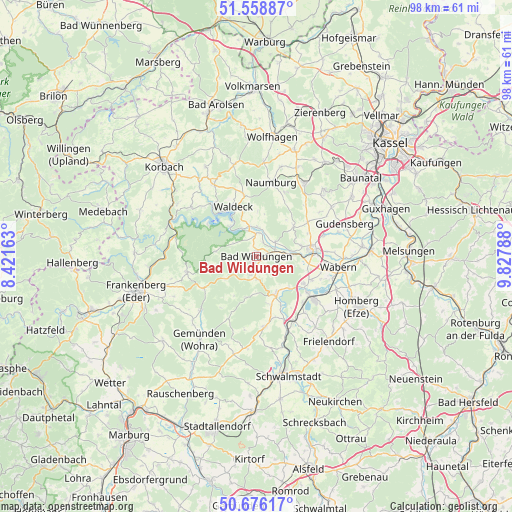
Bad Wildungen GPS coordinates[2]
51° 7' 10.668" North, 9° 7' 29.1" East
| Map corner | latitude | longitude |
|---|---|---|
| Upper-left | 51.55887°, | 8.42163° |
| Center: | 51.11963°, | 9.12475° |
| Lower-right: | 50.67617°, | 9.82788° |
| Map W x H: | 98.1×98.1 km | = 61×61mi |
| max Lat: | 55.01917° ⇑39.8% North |
| Bad Wildungen: | 51.11963° |
| min Lat: | ⇓60.2% South 47.40724° |
| min Long | Bad Wildungen | max Long |
| 5.92978° | 9.12475° | 14.98853° |
| W 36.4%⇐ | ⇒63.6% E |
Elevation
Elevation of Bad Wildungen is 276 m = 906 ft, and this is 26.9 m = 88 ft above average elevation for this country.
| Max E: |
1256 m = 4121 ft | 42.4% |
| Bad Wildungen | 276 m 906 ft | |
| Avg. | 249.1 m = 817 ft | |
Min E: |
-5 m = -16 ft | 57.6% |
See also: Germany elevation on elevation.city.
Geographical zone
Bad Wildungen is located in North temperate zone (between Tropic of Cancer and the Arctic Circle). Distance of this North polar circle is 1717.2 km =1067 mi to North.| Distance of | km | miles | from Bad Wildungen |
|---|---|---|---|
| North Pole | 4323.1 | 2686.2 | to North |
| Arctic Circle | 1717.2 | 1067 | to North |
| Tropic Cancer | 3078.1 | 1912.6 | to South |
| Equator | 5684 | 3531.9 | to South |


Nearby cities:
15 places around Bad Wildungen: (largest is in red/bold)
• Borken
13.9 km =8.6 mi,  126°
126°
• Frankenau
13.6 km =8.5 mi,  257°
257°
• Fritzlar
10.6 km =6.6 mi,  82°
82°
• Gudensberg
18.1 km =11.2 mi,  69°
69°
• Haina
14.7 km =9.1 mi,  225°
225°
• Hemfurth-Edersee
7.9 km =4.9 mi,  321°
321°
• Jesberg
13.4 km =8.3 mi,  172°
172°
• Naumburg
14.6 km =9.1 mi,  11°
11°
• Neuental
14.8 km =9.2 mi,  154°
154°
• Niedenstein
18.1 km =11.2 mi,  45°
45°
• Reinhardshausen
3.6 km =2.2 mi, 255°
• Sachsenhausen
15.9 km =9.9 mi,  329°
329°
• Vöhl
15.8 km =9.8 mi,  307°
307°
• Wabern
15.9 km =9.9 mi,  97°
97°
• Waldeck
10.5 km =6.5 mi,  335°
335°
Sources, notices
• [Note1] Compared only with cities in Germany existing in our database
• [Src1] Map data: © OpenStreetMap contributors (CC-BY-SA)
• [Src2] Other city data from geonames.org with taken over terms of usage.
• [Src3] Geographical zone / Annual Mean Temperature by Robert A. Rohde @ Wikipedia
