Bischofsheim an der Rhön geodata
Bischofsheim an der Rhön (Bavaria) is a populated place; located in Germany in Europe/Berlin (GMT+2) time zone. With population of 5,181 people, there are 2751 cities with bigger population in this country. Compared to other cities in Germany, 54.5% of cities are located further ↑North; 50.2% of cities are located further ←West and 82.7% of cities have lower elevation than Bischofsheim an der Rhön. Note1
Administrative division(s):
- Level 1: Bavaria
- Level 2: Regierungsbezirk Unterfranken
- Level 3: Landkreis Rhön-Grabfeld
- Level 4: Bischofsheim a.d.Rhön
Current local time in Bischofsheim an der Rhön:
01:53 PM, FridayDifference from your time zone: hours


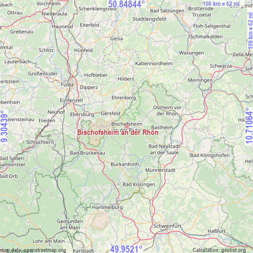
Bischofsheim an der Rhön GPS coordinates[2]
50° 24' 8.604" North, 10° 0' 27.036" East
| Map corner | latitude | longitude |
|---|---|---|
| Upper-left | 50.84844°, | 9.30439° |
| Center: | 50.40239°, | 10.00751° |
| Lower-right: | 49.9521°, | 10.71064° |
| Map W x H: | 99.7×99.7 km | = 62×62mi |
| max Lat: | 55.01917° ⇑54.5% North |
| Bischofsheim an der Rhön: | 50.40239° |
| min Lat: | ⇓45.5% South 47.40724° |
| min Long | Bischofsheim an | max Long |
| 5.92978° | 10.00751° | 14.98853° |
| W 50.2%⇐ | ⇒49.8% E |
Elevation
Elevation of Bischofsheim an der Rhön is 451 m = 1480 ft, and this is 201.9 m = 662 ft above average elevation for this country.
| Max E: |
1256 m = 4121 ft | 17.3% |
| Bischofsheim an der Rhön | 451 m 1480 ft | |
| Avg. | 249.1 m = 817 ft | |
Min E: |
-5 m = -16 ft | 82.7% |
See also: Germany elevation on elevation.city.
Geographical zone
Bischofsheim an der Rhön is located in North temperate zone (between Tropic of Cancer and the Arctic Circle). Distance of this North polar circle is 1797 km =1116.6 mi to North.| Distance of | km | miles | from Bischofsheim an der Rhön |
|---|---|---|---|
| North Pole | 4402.8 | 2735.8 | to North |
| Arctic Circle | 1797 | 1116.6 | to North |
| Tropic Cancer | 2998.3 | 1863.1 | to South |
| Equator | 5604.2 | 3482.3 | to South |


Nearby cities:
15 places around Bischofsheim an der Rhön: (largest is in red/bold)
• Bad Bocklet
15.9 km =9.9 mi,  161°
161°
• Bastheim
13.9 km =8.6 mi,  90°
90°
• Birx
14.9 km =9.3 mi,  11°
11°
• Burkardroth
14.6 km =9.1 mi,  184°
184°
• Frankenheim
16.4 km =10.2 mi,  15°
15°
• Geroda
15.7 km =9.8 mi,  210°
210°
• Gersfeld
8.6 km =5.3 mi,  309°
309°
• Hausen
14.3 km =8.9 mi,  36°
36°
• Hohenroth
15.7 km =9.8 mi,  127°
127°
• Oberelsbach
8.9 km =5.5 mi,  60°
60°
• Poppenhausen
13.7 km =8.5 mi, 313°
• Riedenberg
13.9 km =8.6 mi,  228°
228°
• Sandberg
6 km =3.7 mi, 179°
• Sondheim vor der Rhön
12.7 km =7.9 mi, 56°
• Wildflecken
7.4 km =4.6 mi,  248°
248°
Sources, notices
• [Note1] Compared only with cities in Germany existing in our database
• [Src1] Map data: © OpenStreetMap contributors (CC-BY-SA)
• [Src2] Other city data from geonames.org with taken over terms of usage.
• [Src3] Geographical zone / Annual Mean Temperature by Robert A. Rohde @ Wikipedia
