Gersfeld geodata
Gersfeld (Hesse) is a populated place; located in Germany in Europe/Berlin (GMT+2) time zone. With population of 6,351 people, there are 2350 cities with bigger population in this country. Compared to other cities in Germany, 53.7% of cities are located further ↑North; 51.3% of cities are located further →East and 87.1% of cities have lower elevation than Gersfeld. Note1
Administrative division(s):
- Level 1: Hesse
- Level 2: Regierungsbezirk Kassel
- Level 3: Landkreis Fulda
- Level 4: Gersfeld (Rhön)


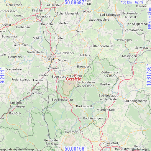
Gersfeld GPS coordinates[2]
50° 27' 4.968" North, 9° 54' 51.192" East
| Map corner | latitude | longitude |
|---|---|---|
| Upper-left | 50.89697°, | 9.2111° |
| Center: | 50.45138°, | 9.91422° |
| Lower-right: | 50.00156°, | 10.61735° |
| Map W x H: | 99.6×99.6 km | = 61.9×61.9mi |
| max Lat: | 55.01917° ⇑53.7% North |
| Gersfeld: | 50.45138° |
| min Lat: | ⇓46.3% South 47.40724° |
| min Long | Gersfeld | max Long |
| 5.92978° | 9.91422° | 14.98853° |
| W 48.7%⇐ | ⇒51.3% E |
Elevation
Elevation of Gersfeld is 486 m = 1594 ft, and this is 236.9 m = 777 ft above average elevation for this country.
| Max E: |
1256 m = 4121 ft | 12.9% |
| Gersfeld | 486 m 1594 ft | |
| Avg. | 249.1 m = 817 ft | |
Min E: |
-5 m = -16 ft | 87.1% |
See also: Germany elevation on elevation.city.
Geographical zone
Gersfeld is located in North temperate zone (between Tropic of Cancer and the Arctic Circle). Distance of this North polar circle is 1791.5 km =1113.2 mi to North.| Distance of | km | miles | from Gersfeld |
|---|---|---|---|
| North Pole | 4397.4 | 2732.4 | to North |
| Arctic Circle | 1791.5 | 1113.2 | to North |
| Tropic Cancer | 3003.7 | 1866.4 | to South |
| Equator | 5609.7 | 3485.7 | to South |


Nearby cities:
15 places around Gersfeld: (largest is in red/bold)
• Birx
13.2 km =8.2 mi,  46°
46°
• Bischofsheim an der Rhön
8.6 km =5.3 mi,  129°
129°
• Dipperz
13.2 km =8.2 mi,  320°
320°
• Eichenzell
16.1 km =10 mi,  287°
287°
• Frankenheim
15 km =9.3 mi, 46°
• Hausen
16.2 km =10.1 mi,  67°
67°
• Hilders
14.8 km =9.2 mi,  25°
25°
• Hofbieber
16 km =9.9 mi,  339°
339°
• Motten
11.8 km =7.3 mi,  238°
238°
• Oberelsbach
14.4 km =8.9 mi,  94°
94°
• Poppenhausen
5.2 km =3.2 mi, 321°
• Riedenberg
15.1 km =9.4 mi,  194°
194°
• Sandberg
13.3 km =8.3 mi,  149°
149°
• Sondheim vor der Rhön
17.2 km =10.7 mi,  84°
84°
• Wildflecken
8.2 km =5.1 mi,  181°
181°
Sources, notices
• [Note1] Compared only with cities in Germany existing in our database
• [Src1] Map data: © OpenStreetMap contributors (CC-BY-SA)
• [Src2] Other city data from geonames.org with taken over terms of usage.
• [Src3] Geographical zone / Annual Mean Temperature by Robert A. Rohde @ Wikipedia
