Linsburg geodata
Linsburg (Lower Saxony) is a seat of a fourth-order administrative division; located in Germany in Europe/Berlin (GMT+2) time zone. With population of 992 people, there are 7213 cities with bigger population in this country. Compared to other cities in Germany, 78.7% of cities are located further ↓South; 60.7% of cities are located further →East and 82% of cities have higher elevation than Linsburg. Note1
Administrative division(s):
- Level 1: Lower Saxony
- Level 3: Landkreis Nienburg/Weser
- Level 4: Linsburg


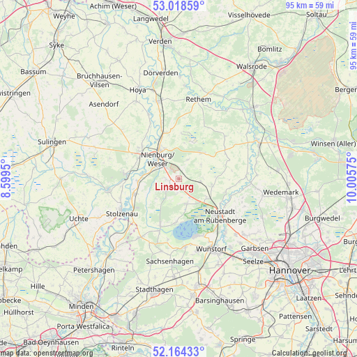
Linsburg GPS coordinates[2]
52° 35' 36.744" North, 9° 18' 9.432" East
| Map corner | latitude | longitude |
|---|---|---|
| Upper-left | 53.01859°, | 8.5995° |
| Center: | 52.59354°, | 9.30262° |
| Lower-right: | 52.16433°, | 10.00575° |
| Map W x H: | 95×95 km | = 59×59mi |
| max Lat: | 55.01917° ⇑21.3% North |
| Linsburg: | 52.59354° |
| min Lat: | ⇓78.7% South 47.40724° |
| min Long | Linsburg | max Long |
| 5.92978° | 9.30262° | 14.98853° |
| W 39.3%⇐ | ⇒60.7% E |
Elevation
Elevation of Linsburg is 42 m = 138 ft, and this is 207.1 m = 679 ft below average elevation for this country.
| Max E: |
1256 m = 4121 ft | 82% |
| Avg. | 249.1 m = 817 ft | |
| Linsburg | 42 m = 138 ft | |
Min E: |
-5 m = -16 ft | 18% |
See also: Germany elevation on elevation.city.
Geographical zone
Linsburg is located in North temperate zone (between Tropic of Cancer and the Arctic Circle). Distance of this North polar circle is 1553.3 km =965.2 mi to North.| Distance of | km | miles | from Linsburg |
|---|---|---|---|
| North Pole | 4159.2 | 2584.4 | to North |
| Arctic Circle | 1553.3 | 965.2 | to North |
| Tropic Cancer | 3241.9 | 2014.4 | to South |
| Equator | 5847.9 | 3633.7 | to South |


Nearby cities:
15 places around Linsburg: (largest is in red/bold)
• Binnen
11.7 km =7.3 mi,  282°
282°
• Drakenburg
12.1 km =7.5 mi,  329°
329°
• Estorf
10.9 km =6.8 mi,  267°
267°
• Haßbergen
16.2 km =10.1 mi,  343°
343°
• Heemsen
12.1 km =7.5 mi,  348°
348°
• Husum
4.6 km =2.9 mi,  229°
229°
• Landesbergen
12.7 km =7.9 mi,  250°
250°
• Liebenau
13.9 km =8.6 mi, 274°
• Marklohe
13.7 km =8.5 mi,  307°
307°
• Neustadt am Rübenberge
14.5 km =9 mi,  133°
133°
• Nienburg
8 km =5 mi,  316°
316°
• Rehburg-Loccum
15.5 km =9.6 mi,  206°
206°
• Röhrsen
13.9 km =8.6 mi, 339°
• Steimbke
9.1 km =5.7 mi,  41°
41°
• Stöckse
5.8 km =3.6 mi,  25°
25°
Sources, notices
• [Note1] Compared only with cities in Germany existing in our database
• [Src1] Map data: © OpenStreetMap contributors (CC-BY-SA)
• [Src2] Other city data from geonames.org with taken over terms of usage.
• [Src3] Geographical zone / Annual Mean Temperature by Robert A. Rohde @ Wikipedia
