Beilstein geodata
Beilstein (Baden-Württemberg) is a populated place; located in Germany in Europe/Berlin (GMT+2) time zone. With population of 6,103 people, there are 2430 cities with bigger population in this country. Compared to other cities in Germany, 82.5% of cities are located further ↑North; 60.6% of cities are located further →East and 54.3% of cities have lower elevation than Beilstein. Note1
Administrative division(s):
- Level 1: Baden-Württemberg
- Level 2: Regierungsbezirk Stuttgart
- Level 3: Landkreis Heilbronn
- Level 4: Beilstein


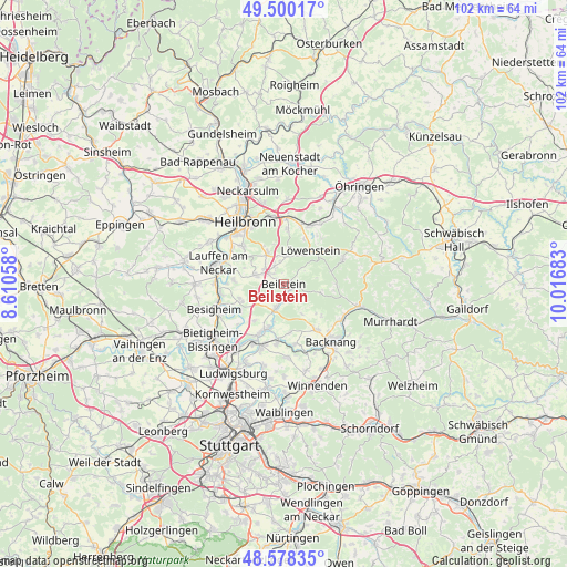
Beilstein GPS coordinates[2]
49° 2' 29.04" North, 9° 18' 49.32" East
| Map corner | latitude | longitude |
|---|---|---|
| Upper-left | 49.50017°, | 8.61058° |
| Center: | 49.0414°, | 9.3137° |
| Lower-right: | 48.57835°, | 10.01683° |
| Map W x H: | 102.5×102.5 km | = 63.7×63.7mi |
| max Lat: | 55.01917° ⇑82.5% North |
| Beilstein: | 49.0414° |
| min Lat: | ⇓17.5% South 47.40724° |
| min Long | Beilstein | max Long |
| 5.92978° | 9.3137° | 14.98853° |
| W 39.4%⇐ | ⇒60.6% E |
Elevation
Elevation of Beilstein is 254 m = 833 ft, and this is 4.9 m = 16 ft above average elevation for this country.
| Max E: |
1256 m = 4121 ft | 45.7% |
| Beilstein | 254 m 833 ft | |
| Avg. | 249.1 m = 817 ft | |
Min E: |
-5 m = -16 ft | 54.3% |
See also: Germany elevation on elevation.city.
Geographical zone
Beilstein is located in North temperate zone (between Tropic of Cancer and the Arctic Circle). Distance of this North polar circle is 1948.3 km =1210.6 mi to North.| Distance of | km | miles | from Beilstein |
|---|---|---|---|
| North Pole | 4554.2 | 2829.8 | to North |
| Arctic Circle | 1948.3 | 1210.6 | to North |
| Tropic Cancer | 2847 | 1769 | to South |
| Equator | 5452.9 | 3388.3 | to South |


Nearby cities:
15 places around Beilstein: (largest is in red/bold)
• Abstatt
3.4 km =2.1 mi,  330°
330°
• Aspach
10.4 km =6.5 mi,  142°
142°
• Flein
10.2 km =6.3 mi,  312°
312°
• Großbottwar
4.7 km =2.9 mi,  198°
198°
• Ilsfeld
5.2 km =3.2 mi,  287°
287°
• Lehrensteinsfeld
10 km =6.2 mi,  5°
5°
• Löwenstein
7.7 km =4.8 mi,  38°
38°
• Mundelsheim
8.9 km =5.5 mi,  239°
239°
• Murr
9.7 km =6 mi, 204°
• Neckarwestheim
9 km =5.6 mi,  273°
273°
• Oberstenfeld
1.8 km =1.1 mi,  163°
163°
• Spiegelberg
9.5 km =5.9 mi,  90°
90°
• Steinheim am der Murr
8.6 km =5.3 mi, 198°
• Talheim
9.9 km =6.2 mi,  297°
297°
• Untergruppenbach
6 km =3.7 mi, 332°
Sources, notices
• [Note1] Compared only with cities in Germany existing in our database
• [Src1] Map data: © OpenStreetMap contributors (CC-BY-SA)
• [Src2] Other city data from geonames.org with taken over terms of usage.
• [Src3] Geographical zone / Annual Mean Temperature by Robert A. Rohde @ Wikipedia
