Bärnau geodata
Bärnau (Bavaria) is a populated place; located in Germany in Europe/Berlin (GMT+2) time zone. With population of 3,475 people, there are 3633 cities with bigger population in this country. Compared to other cities in Germany, 68.7% of cities are located further ↑North; 87.3% of cities are located further ←West and 95.4% of cities have lower elevation than Bärnau. Note1
Administrative division(s):
- Level 1: Bavaria
- Level 2: Upper Palatinate
- Level 3: Landkreis Tirschenreuth
- Level 4: Bärnau


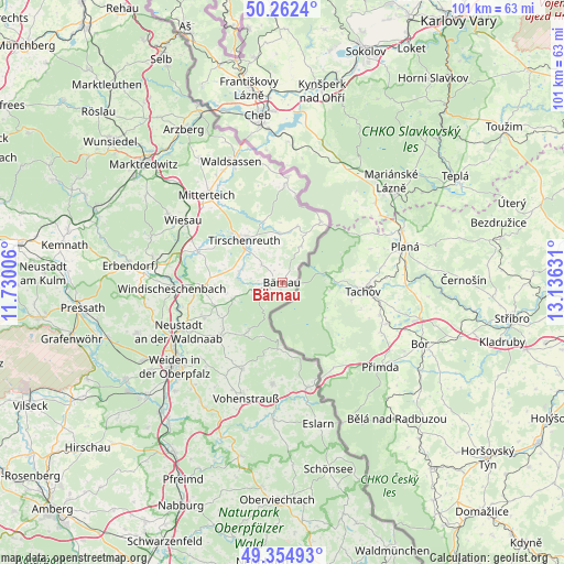
Bärnau GPS coordinates[2]
49° 48' 38.844" North, 12° 25' 59.448" East
| Map corner | latitude | longitude |
|---|---|---|
| Upper-left | 50.2624°, | 11.73006° |
| Center: | 49.81079°, | 12.43318° |
| Lower-right: | 49.35493°, | 13.13631° |
| Map W x H: | 100.9×100.9 km | = 62.7×62.7mi |
| max Lat: | 55.01917° ⇑68.7% North |
| Bärnau: | 49.81079° |
| min Lat: | ⇓31.3% South 47.40724° |
| min Long | Bärnau | max Long |
| 5.92978° | 12.43318° | 14.98853° |
| W 87.3%⇐ | ⇒12.7% E |
Elevation
Elevation of Bärnau is 608 m = 1995 ft, and this is 358.9 m = 1177 ft above average elevation for this country.
| Max E: |
1256 m = 4121 ft | 4.6% |
| Bärnau | 608 m 1995 ft | |
| Avg. | 249.1 m = 817 ft | |
Min E: |
-5 m = -16 ft | 95.4% |
See also: Germany elevation on elevation.city.
Geographical zone
Bärnau is located in North temperate zone (between Tropic of Cancer and the Arctic Circle). Distance of this North polar circle is 1862.7 km =1157.4 mi to North.| Distance of | km | miles | from Bärnau |
|---|---|---|---|
| North Pole | 4468.6 | 2776.7 | to North |
| Arctic Circle | 1862.7 | 1157.4 | to North |
| Tropic Cancer | 2932.5 | 1822.2 | to South |
| Equator | 5538.4 | 3441.4 | to South |


Nearby cities:
15 places around Bärnau: (largest is in red/bold)
• Falkenberg
15.7 km =9.8 mi,  289°
289°
• Flossenbürg
10.5 km =6.5 mi,  214°
214°
• Floß
14.9 km =9.3 mi,  229°
229°
• Georgenberg
12 km =7.5 mi,  184°
184°
• Konradsreuth
12.5 km =7.8 mi, 232°
• Leonberg
18.5 km =11.5 mi,  325°
325°
• Mähring
12.9 km =8 mi,  30°
30°
• Neualbenreuth
18.9 km =11.7 mi,  2°
2°
• Pleystein
18.1 km =11.2 mi,  186°
186°
• Püchersreuth
15.9 km =9.9 mi,  244°
244°
• Schwarzenbach
4.9 km =3 mi,  309°
309°
• Störnstein
18.5 km =11.5 mi, 241°
• Tirschenreuth
10.8 km =6.7 mi,  317°
317°
• Waidhaus
19.3 km =12 mi,  166°
166°
• Waldthurn
17.1 km =10.6 mi, 205°
Sources, notices
• [Note1] Compared only with cities in Germany existing in our database
• [Src1] Map data: © OpenStreetMap contributors (CC-BY-SA)
• [Src2] Other city data from geonames.org with taken over terms of usage.
• [Src3] Geographical zone / Annual Mean Temperature by Robert A. Rohde @ Wikipedia
