Konradsreuth geodata
Konradsreuth (Bavaria) is a populated place; located in Germany in Europe/Berlin (GMT+2) time zone. With population of 1,946 people, there are 5142 cities with bigger population in this country. Compared to other cities in Germany, 70.3% of cities are located further ↑North; 85.8% of cities are located further ←West and 90.5% of cities have lower elevation than Konradsreuth. Note1
Administrative division(s):
- Level 1: Bavaria
- Level 2: Upper Palatinate
- Level 3: Landkreis Neustadt an der Waldnaab
- Level 4: Floß, Markt


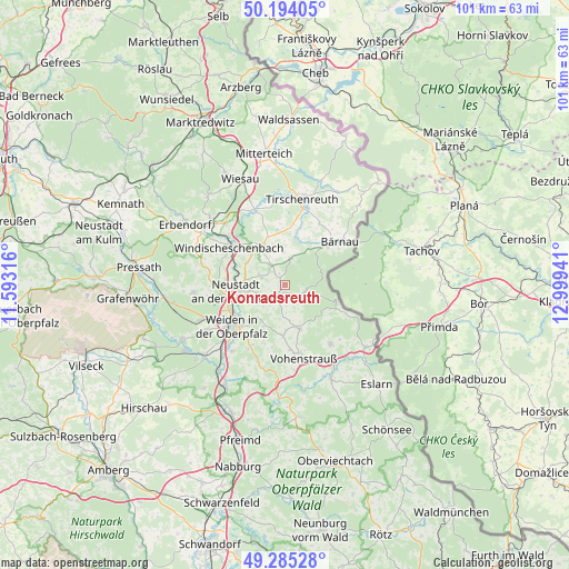
Konradsreuth GPS coordinates[2]
49° 44' 30.444" North, 12° 17' 46.608" East
| Map corner | latitude | longitude |
|---|---|---|
| Upper-left | 50.19405°, | 11.59316° |
| Center: | 49.74179°, | 12.29628° |
| Lower-right: | 49.28528°, | 12.99941° |
| Map W x H: | 101×101 km | = 62.8×62.8mi |
| max Lat: | 55.01917° ⇑70.3% North |
| Konradsreuth: | 49.74179° |
| min Lat: | ⇓29.7% South 47.40724° |
| min Long | Konradsreuth | max Long |
| 5.92978° | 12.29628° | 14.98853° |
| W 85.8%⇐ | ⇒14.2% E |
Elevation
Elevation of Konradsreuth is 520 m = 1706 ft, and this is 270.9 m = 889 ft above average elevation for this country.
| Max E: |
1256 m = 4121 ft | 9.5% |
| Konradsreuth | 520 m 1706 ft | |
| Avg. | 249.1 m = 817 ft | |
Min E: |
-5 m = -16 ft | 90.5% |
See also: Germany elevation on elevation.city.
Geographical zone
Konradsreuth is located in North temperate zone (between Tropic of Cancer and the Arctic Circle). Distance of this North polar circle is 1870.4 km =1162.2 mi to North.| Distance of | km | miles | from Konradsreuth |
|---|---|---|---|
| North Pole | 4476.3 | 2781.4 | to North |
| Arctic Circle | 1870.4 | 1162.2 | to North |
| Tropic Cancer | 2924.8 | 1817.4 | to South |
| Equator | 5530.8 | 3436.7 | to South |


Nearby cities:
15 places around Konradsreuth: (largest is in red/bold)
• Bechtsrieth
12.4 km =7.7 mi,  209°
209°
• Bärnau
12.5 km =7.8 mi,  52°
52°
• Flossenbürg
4 km =2.5 mi,  103°
103°
• Floß
2.5 km =1.6 mi,  216°
216°
• Georgenberg
9.9 km =6.2 mi,  115°
115°
• Neustadt an der Waldnaab
8.6 km =5.3 mi,  263°
263°
• Pleystein
13 km =8.1 mi,  142°
142°
• Püchersreuth
4.6 km =2.9 mi,  281°
281°
• Schwarzenbach
12.3 km =7.6 mi,  29°
29°
• Störnstein
6.6 km =4.1 mi, 260°
• Theisseil
7.6 km =4.7 mi, 220°
• Vohenstrauß
13.5 km =8.4 mi,  167°
167°
• Waldthurn
8.1 km =5 mi,  162°
162°
• Weiden
12.4 km =7.7 mi,  234°
234°
• Windischeschenbach
12 km =7.5 mi,  303°
303°
Sources, notices
• [Note1] Compared only with cities in Germany existing in our database
• [Src1] Map data: © OpenStreetMap contributors (CC-BY-SA)
• [Src2] Other city data from geonames.org with taken over terms of usage.
• [Src3] Geographical zone / Annual Mean Temperature by Robert A. Rohde @ Wikipedia
