Georgenberg geodata
Georgenberg (Bavaria) is a seat of a fourth-order administrative division; located in Germany in Europe/Berlin (GMT+2) time zone. With population of 1,507 people, there are 5868 cities with bigger population in this country. Compared to other cities in Germany, 71.3% of cities are located further ↑North; 87.2% of cities are located further ←West and 95.1% of cities have lower elevation than Georgenberg. Note1
Administrative division(s):
- Level 1: Bavaria
- Level 2: Upper Palatinate
- Level 3: Landkreis Neustadt an der Waldnaab
- Level 4: Georgenberg


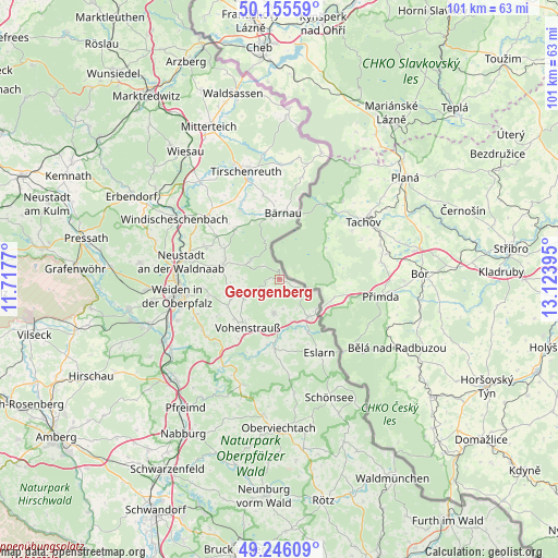
Georgenberg GPS coordinates[2]
49° 42' 10.692" North, 12° 25' 14.952" East
| Map corner | latitude | longitude |
|---|---|---|
| Upper-left | 50.15559°, | 11.7177° |
| Center: | 49.70297°, | 12.42082° |
| Lower-right: | 49.24609°, | 13.12395° |
| Map W x H: | 101.1×101.1 km | = 62.8×62.8mi |
| max Lat: | 55.01917° ⇑71.3% North |
| Georgenberg: | 49.70297° |
| min Lat: | ⇓28.7% South 47.40724° |
| min Long | Georgenberg | max Long |
| 5.92978° | 12.42082° | 14.98853° |
| W 87.2%⇐ | ⇒12.8% E |
Elevation
Elevation of Georgenberg is 601 m = 1972 ft, and this is 351.9 m = 1155 ft above average elevation for this country.
| Max E: |
1256 m = 4121 ft | 4.9% |
| Georgenberg | 601 m 1972 ft | |
| Avg. | 249.1 m = 817 ft | |
Min E: |
-5 m = -16 ft | 95.1% |
See also: Germany elevation on elevation.city.
Geographical zone
Georgenberg is located in North temperate zone (between Tropic of Cancer and the Arctic Circle). Distance of this North polar circle is 1874.7 km =1164.9 mi to North.| Distance of | km | miles | from Georgenberg |
|---|---|---|---|
| North Pole | 4480.6 | 2784.1 | to North |
| Arctic Circle | 1874.7 | 1164.9 | to North |
| Tropic Cancer | 2920.5 | 1814.7 | to South |
| Equator | 5526.5 | 3434 | to South |


Nearby cities:
15 places around Georgenberg: (largest is in red/bold)
• Bechtsrieth
16.5 km =10.3 mi,  246°
246°
• Bärnau
12 km =7.5 mi,  4°
4°
• Eslarn
15.1 km =9.4 mi,  151°
151°
• Flossenbürg
6.1 km =3.8 mi,  303°
303°
• Floß
10.7 km =6.6 mi,  282°
282°
• Konradsreuth
9.9 km =6.2 mi, 295°
• Moosbach
12.7 km =7.9 mi,  183°
183°
• Pleystein
6.1 km =3.8 mi,  189°
189°
• Püchersreuth
14.5 km =9 mi,  291°
291°
• Schwarzenbach
15.4 km =9.6 mi,  349°
349°
• Störnstein
15.8 km =9.8 mi, 281°
• Theisseil
14 km =8.7 mi,  264°
264°
• Vohenstrauß
10.6 km =6.6 mi,  214°
214°
• Waidhaus
8.6 km =5.3 mi,  141°
141°
• Waldthurn
7.4 km =4.6 mi,  242°
242°
Sources, notices
• [Note1] Compared only with cities in Germany existing in our database
• [Src1] Map data: © OpenStreetMap contributors (CC-BY-SA)
• [Src2] Other city data from geonames.org with taken over terms of usage.
• [Src3] Geographical zone / Annual Mean Temperature by Robert A. Rohde @ Wikipedia
