Bockhorn geodata
Bockhorn (Lower Saxony) is a seat of a fourth-order administrative division; located in Germany in Europe/Berlin (GMT+2) time zone. With population of 8,924 people, there are 1805 cities with bigger population in this country. Compared to other cities in Germany, 84.5% of cities are located further ↓South; 76.8% of cities are located further →East and 96.6% of cities have higher elevation than Bockhorn. Note1


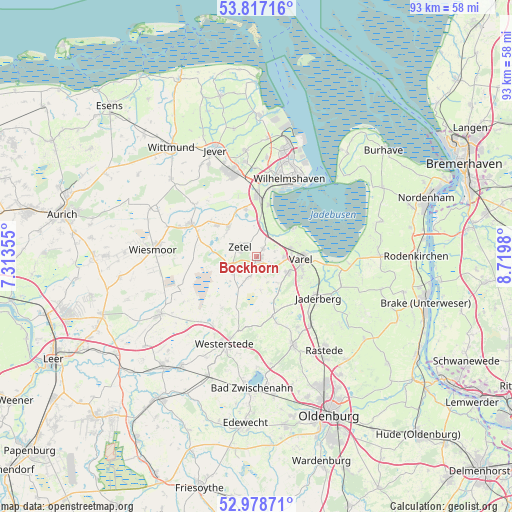
Bockhorn GPS coordinates[2]
53° 24' 0" North, 8° 1' 0.012" East
| Map corner | latitude | longitude |
|---|---|---|
| Upper-left | 53.81716°, | 7.31355° |
| Center: | 53.4°, | 8.01667° |
| Lower-right: | 52.97871°, | 8.7198° |
| Map W x H: | 93.2×93.2 km | = 57.9×57.9mi |
| max Lat: | 55.01917° ⇑15.5% North |
| Bockhorn: | 53.4° |
| min Lat: | ⇓84.5% South 47.40724° |
| min Long | Bockhorn | max Long |
| 5.92978° | 8.01667° | 14.98853° |
| W 23.2%⇐ | ⇒76.8% E |
Elevation
Elevation of Bockhorn is 5 m = 16 ft, and this is 244.1 m = 801 ft below average elevation for this country.
| Max E: |
1256 m = 4121 ft | 96.6% |
| Avg. | 249.1 m = 817 ft | |
| Bockhorn | 5 m = 16 ft | |
Min E: |
-5 m = -16 ft | 3.4% |
See also: Germany elevation on elevation.city.
Geographical zone
Bockhorn is located in North temperate zone (between Tropic of Cancer and the Arctic Circle). Distance of this North polar circle is 1463.7 km =909.5 mi to North.| Distance of | km | miles | from Bockhorn |
|---|---|---|---|
| North Pole | 4069.5 | 2528.7 | to North |
| Arctic Circle | 1463.7 | 909.5 | to North |
| Tropic Cancer | 3331.6 | 2070.2 | to South |
| Equator | 5937.5 | 3689.4 | to South |


Nearby cities:
15 places around Bockhorn: (largest is in red/bold)
• Bad Zwischenahn
24.1 km =15 mi,  182°
182°
• Fedderwarden
18 km =11.2 mi,  5°
5°
• Firrel
24.4 km =15.2 mi,  252°
252°
• Friedeburg
13.4 km =8.3 mi,  294°
294°
• Jever
20.8 km =12.9 mi,  337°
337°
• Rastede
20.6 km =12.8 mi,  143°
143°
• Sande
11.7 km =7.3 mi,  359°
359°
• Schortens
15.5 km =9.6 mi, 343°
• Sillenstede
19.5 km =12.1 mi,  353°
353°
• Varel
7.9 km =4.9 mi,  92°
92°
• Westerstede
17 km =10.6 mi,  200°
200°
• Wiefelstede
18 km =11.2 mi,  158°
158°
• Wiesmoor
18.9 km =11.7 mi,  275°
275°
• Wilhelmshaven
15.8 km =9.8 mi,  23°
23°
• Zetel
2.9 km =1.8 mi,  309°
309°
Sources, notices
• [Note1] Compared only with cities in Germany existing in our database
• [Src1] Map data: © OpenStreetMap contributors (CC-BY-SA)
• [Src2] Other city data from geonames.org with taken over terms of usage.
• [Src3] Geographical zone / Annual Mean Temperature by Robert A. Rohde @ Wikipedia
