Albbruck geodata
Albbruck (Baden-Württemberg) is a seat of a fourth-order administrative division; located in Germany in Europe/Berlin (GMT+2) time zone. With population of 7,372 people, there are 2097 cities with bigger population in this country. Compared to other cities in Germany, 99.7% of cities are located further ↑North; 75% of cities are located further →East and 64% of cities have lower elevation than Albbruck. Note1
Administrative division(s):
- Level 1: Baden-Württemberg
- Level 2: Freiburg Region
- Level 3: Landkreis Waldshut
- Level 4: Albbruck


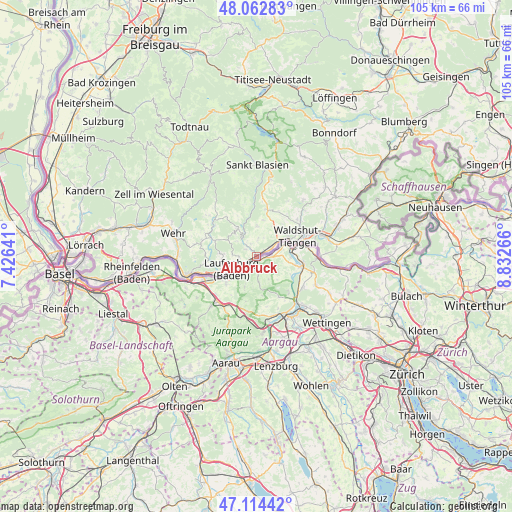
Albbruck GPS coordinates[2]
47° 35' 26.772" North, 8° 7' 46.344" East
| Map corner | latitude | longitude |
|---|---|---|
| Upper-left | 48.06283°, | 7.42641° |
| Center: | 47.59077°, | 8.12954° |
| Lower-right: | 47.11442°, | 8.83266° |
| Map W x H: | 105.5×105.5 km | = 65.6×65.6mi |
| max Lat: | 55.01917° ⇑99.7% North |
| Albbruck: | 47.59077° |
| min Lat: | ⇓0.3% South 47.40724° |
| min Long | Albbruck | max Long |
| 5.92978° | 8.12954° | 14.98853° |
| W 25%⇐ | ⇒75% E |
Elevation
Elevation of Albbruck is 315 m = 1033 ft, and this is 65.9 m = 216 ft above average elevation for this country.
| Max E: |
1256 m = 4121 ft | 36% |
| Albbruck | 315 m 1033 ft | |
| Avg. | 249.1 m = 817 ft | |
Min E: |
-5 m = -16 ft | 64% |
See also: Germany elevation on elevation.city.
Geographical zone
Albbruck is located in North temperate zone (between Tropic of Cancer and the Arctic Circle). Distance of this North polar circle is 2109.6 km =1310.8 mi to North.| Distance of | km | miles | from Albbruck |
|---|---|---|---|
| North Pole | 4715.5 | 2930.1 | to North |
| Arctic Circle | 2109.6 | 1310.8 | to North |
| Tropic Cancer | 2685.7 | 1668.8 | to South |
| Equator | 5291.6 | 3288 | to South |


Nearby cities:
15 places around Albbruck: (largest is in red/bold)
• Bad Säckingen
14.4 km =8.9 mi,  253°
253°
• Dachsberg
15.6 km =9.7 mi,  351°
351°
• Dogern
3.5 km =2.2 mi,  53°
53°
• Görwihl
7.1 km =4.4 mi,  324°
324°
• Herrischried
12.9 km =8 mi,  311°
311°
• Häusern
17.9 km =11.1 mi,  8°
8°
• Höchenschwand
16.1 km =10 mi, 9°
• Ibach
16.5 km =10.3 mi,  343°
343°
• Lauchringen
14.4 km =8.9 mi,  73°
73°
• Laufenburg
5.9 km =3.7 mi,  241°
241°
• Murg
9 km =5.6 mi, 243°
• Rickenbach
11.7 km =7.3 mi,  285°
285°
• Waldshut-Tiengen
7.5 km =4.7 mi,  61°
61°
• Wehr
17.4 km =10.8 mi,  284°
284°
• Weilheim
11.5 km =7.1 mi,  42°
42°
Sources, notices
• [Note1] Compared only with cities in Germany existing in our database
• [Src1] Map data: © OpenStreetMap contributors (CC-BY-SA)
• [Src2] Other city data from geonames.org with taken over terms of usage.
• [Src3] Geographical zone / Annual Mean Temperature by Robert A. Rohde @ Wikipedia
