Rheinbach geodata
Rheinbach (North Rhine-Westphalia) is a populated place; located in Germany in Europe/Berlin (GMT+2) time zone. With population of 26,262 people, there are 553 cities with bigger population in this country. Compared to other cities in Germany, 50.1% of cities are located further ↓South; 94% of cities are located further →East and 55.9% of cities have higher elevation than Rheinbach. Note1
Administrative division(s):
- Level 1: North Rhine-Westphalia
- Level 2: Regierungsbezirk Köln
- Level 3: Rhein-Sieg-Kreis
- Level 4: Rheinbach


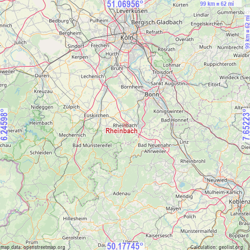
Rheinbach GPS coordinates[2]
50° 37' 32.232" North, 6° 56' 56.796" East
| Map corner | latitude | longitude |
|---|---|---|
| Upper-left | 51.06956°, | 6.24598° |
| Center: | 50.62562°, | 6.94911° |
| Lower-right: | 50.17745°, | 7.65223° |
| Map W x H: | 99.2×99.2 km | = 61.6×61.6mi |
| max Lat: | 55.01917° ⇑49.9% North |
| Rheinbach: | 50.62562° |
| min Lat: | ⇓50.1% South 47.40724° |
| min Long | Rheinbach | max Long |
| 5.92978° | 6.94911° | 14.98853° |
| W 6%⇐ | ⇒94% E |
Elevation
Elevation of Rheinbach is 182 m = 597 ft, and this is 67.1 m = 220 ft below average elevation for this country.
| Max E: |
1256 m = 4121 ft | 55.9% |
| Avg. | 249.1 m = 817 ft | |
| Rheinbach | 182 m = 597 ft | |
Min E: |
-5 m = -16 ft | 44.1% |
See also: Germany elevation on elevation.city.
Geographical zone
Rheinbach is located in North temperate zone (between Tropic of Cancer and the Arctic Circle). Distance of this North polar circle is 1772.1 km =1101.1 mi to North.| Distance of | km | miles | from Rheinbach |
|---|---|---|---|
| North Pole | 4378 | 2720.4 | to North |
| Arctic Circle | 1772.1 | 1101.1 | to North |
| Tropic Cancer | 3023.1 | 1878.5 | to South |
| Equator | 5629 | 3497.7 | to South |


Nearby cities:
15 places around Rheinbach: (largest is in red/bold)
• Alfter
12.9 km =8 mi,  21°
21°
• Altenahr
12.5 km =7.8 mi,  165°
165°
• Bad Münstereifel
15.1 km =9.4 mi,  239°
239°
• Bad Neuenahr-Ahrweiler
14.7 km =9.1 mi,  128°
128°
• Berg
7.8 km =4.8 mi,  180°
180°
• Bornheim
15.6 km =9.7 mi,  10°
10°
• Dernau
12.5 km =7.8 mi,  145°
145°
• Euskirchen
12.1 km =7.5 mi,  288°
288°
• Kalenborn
9.1 km =5.7 mi,  156°
156°
• Kirchsahr
12 km =7.5 mi,  196°
196°
• Lind
14 km =8.7 mi, 184°
• Mayschoß
12.6 km =7.8 mi, 157°
• Meckenheim
5.7 km =3.5 mi,  91°
91°
• Rech
13.5 km =8.4 mi, 153°
• Wachtberg
10.7 km =6.6 mi, 85°
Sources, notices
• [Note1] Compared only with cities in Germany existing in our database
• [Src1] Map data: © OpenStreetMap contributors (CC-BY-SA)
• [Src2] Other city data from geonames.org with taken over terms of usage.
• [Src3] Geographical zone / Annual Mean Temperature by Robert A. Rohde @ Wikipedia
