Bad Aibling geodata
Bad Aibling (Bavaria) is a populated place; located in Germany in Europe/Berlin (GMT+2) time zone. With population of 17,672 people, there are 900 cities with bigger population in this country. Compared to other cities in Germany, 97% of cities are located further ↑North; 81.9% of cities are located further ←West and 86.6% of cities have lower elevation than Bad Aibling. Note1
Administrative division(s):
- Level 1: Bavaria
- Level 2: Upper Bavaria
- Level 3: Landkreis Rosenheim
- Level 4: Bad Aibling


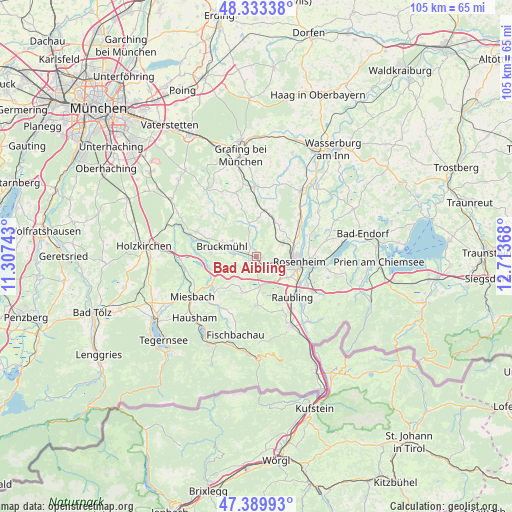
Bad Aibling GPS coordinates[2]
47° 51' 49.68" North, 12° 0' 37.98" East
| Map corner | latitude | longitude |
|---|---|---|
| Upper-left | 48.33338°, | 11.30743° |
| Center: | 47.8638°, | 12.01055° |
| Lower-right: | 47.38993°, | 12.71368° |
| Map W x H: | 104.9×104.9 km | = 65.2×65.2mi |
| max Lat: | 55.01917° ⇑97% North |
| Bad Aibling: | 47.8638° |
| min Lat: | ⇓3% South 47.40724° |
| min Long | Bad Aibling | max Long |
| 5.92978° | 12.01055° | 14.98853° |
| W 81.9%⇐ | ⇒18.1% E |
Elevation
Elevation of Bad Aibling is 482 m = 1581 ft, and this is 232.9 m = 764 ft above average elevation for this country.
| Max E: |
1256 m = 4121 ft | 13.4% |
| Bad Aibling | 482 m 1581 ft | |
| Avg. | 249.1 m = 817 ft | |
Min E: |
-5 m = -16 ft | 86.6% |
See also: Germany elevation on elevation.city.
Geographical zone
Bad Aibling is located in North temperate zone (between Tropic of Cancer and the Arctic Circle). Distance of this North polar circle is 2079.2 km =1292 mi to North.| Distance of | km | miles | from Bad Aibling |
|---|---|---|---|
| North Pole | 4685.1 | 2911.2 | to North |
| Arctic Circle | 2079.2 | 1292 | to North |
| Tropic Cancer | 2716 | 1687.6 | to South |
| Equator | 5322 | 3306.9 | to South |


Nearby cities:
15 places around Bad Aibling: (largest is in red/bold)
• Altenmarkt
13.2 km =8.2 mi,  135°
135°
• Bad Feilnbach
10.1 km =6.3 mi,  180°
180°
• Bruckmühl
7.6 km =4.7 mi,  282°
282°
• Feldkirchen-Westerham
13.4 km =8.3 mi,  291°
291°
• Großkarolinenfeld
6.1 km =3.8 mi,  60°
60°
• Hohenthann
13.3 km =8.3 mi,  342°
342°
• Irschenberg
7.8 km =4.8 mi,  244°
244°
• Kolbermoor
4.5 km =2.8 mi,  110°
110°
• Raubling
11.1 km =6.9 mi, 137°
• Rosenheim
8.4 km =5.2 mi,  95°
95°
• Rott
8.5 km =5.3 mi,  42°
42°
• Schechen
11.1 km =6.9 mi,  49°
49°
• Stephanskirchen
13.1 km =8.1 mi,  94°
94°
• Tuntenhausen
7.9 km =4.9 mi,  2°
2°
• Vagen
9.5 km =5.9 mi, 276°
Sources, notices
• [Note1] Compared only with cities in Germany existing in our database
• [Src1] Map data: © OpenStreetMap contributors (CC-BY-SA)
• [Src2] Other city data from geonames.org with taken over terms of usage.
• [Src3] Geographical zone / Annual Mean Temperature by Robert A. Rohde @ Wikipedia
