Rott geodata
Rott (Bavaria) is a populated place; located in Germany in Europe/Berlin (GMT+2) time zone. With population of 3,616 people, there are 3525 cities with bigger population in this country. Compared to other cities in Germany, 96.4% of cities are located further ↑North; 83% of cities are located further ←West and 84.5% of cities have lower elevation than Rott. Note1
Administrative division(s):
- Level 1: Bavaria
- Level 2: Upper Bavaria
- Level 3: Landkreis Rosenheim
- Level 4: Großkarolinenfeld


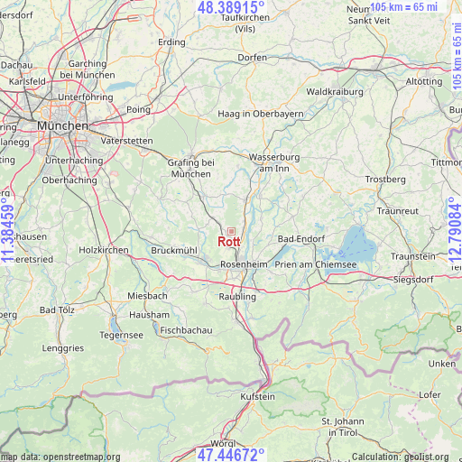
Rott GPS coordinates[2]
47° 55' 12.288" North, 12° 5' 15.756" East
| Map corner | latitude | longitude |
|---|---|---|
| Upper-left | 48.38915°, | 11.38459° |
| Center: | 47.92008°, | 12.08771° |
| Lower-right: | 47.44672°, | 12.79084° |
| Map W x H: | 104.8×104.8 km | = 65.1×65.1mi |
| max Lat: | 55.01917° ⇑96.4% North |
| Rott: | 47.92008° |
| min Lat: | ⇓3.6% South 47.40724° |
| min Long | Rott | max Long |
| 5.92978° | 12.08771° | 14.98853° |
| W 83%⇐ | ⇒17% E |
Elevation
Elevation of Rott is 465 m = 1526 ft, and this is 215.9 m = 708 ft above average elevation for this country.
| Max E: |
1256 m = 4121 ft | 15.5% |
| Rott | 465 m 1526 ft | |
| Avg. | 249.1 m = 817 ft | |
Min E: |
-5 m = -16 ft | 84.5% |
See also: Germany elevation on elevation.city.
Geographical zone
Rott is located in North temperate zone (between Tropic of Cancer and the Arctic Circle). Distance of this North polar circle is 2073 km =1288.1 mi to North.| Distance of | km | miles | from Rott |
|---|---|---|---|
| North Pole | 4678.8 | 2907.3 | to North |
| Arctic Circle | 2073 | 1288.1 | to North |
| Tropic Cancer | 2722.3 | 1691.6 | to South |
| Equator | 5328.2 | 3310.8 | to South |


Nearby cities:
15 places around Rott: (largest is in red/bold)
• Aßling
10.1 km =6.3 mi,  323°
323°
• Bad Aibling
8.5 km =5.3 mi,  222°
222°
• Emmering
8.9 km =5.5 mi,  344°
344°
• Eschenlohe
11.6 km =7.2 mi, 338°
• Griesstätt
10.6 km =6.6 mi,  39°
39°
• Großkarolinenfeld
3.3 km =2.1 mi,  188°
188°
• Kolbermoor
8 km =5 mi, 191°
• Prutting
9.1 km =5.7 mi,  109°
109°
• Ramerberg
11.7 km =7.3 mi,  21°
21°
• Rosenheim
7.5 km =4.7 mi,  159°
159°
• Schechen
2.9 km =1.8 mi,  69°
69°
• Stephanskirchen
10.4 km =6.5 mi,  135°
135°
• Söchtenau
10.6 km =6.6 mi,  83°
83°
• Tuntenhausen
5.7 km =3.5 mi,  287°
287°
• Vogtareuth
7.6 km =4.7 mi, 66°
Sources, notices
• [Note1] Compared only with cities in Germany existing in our database
• [Src1] Map data: © OpenStreetMap contributors (CC-BY-SA)
• [Src2] Other city data from geonames.org with taken over terms of usage.
• [Src3] Geographical zone / Annual Mean Temperature by Robert A. Rohde @ Wikipedia
