Stendal geodata
Stendal (Saxony-Anhalt) is a seat of a third-order administrative division; located in Germany in Europe/Berlin (GMT+2) time zone. With population of 37,722 people, there are 353 cities with bigger population in this country. Compared to other cities in Germany, 78.8% of cities are located further ↓South; 79.7% of cities are located further ←West and 85.4% of cities have higher elevation than Stendal. Note1


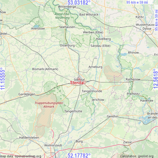
Stendal GPS coordinates[2]
52° 36' 24.84" North, 11° 51' 31.212" East
| Map corner | latitude | longitude |
|---|---|---|
| Upper-left | 53.03182°, | 11.15555° |
| Center: | 52.6069°, | 11.85867° |
| Lower-right: | 52.17782°, | 12.5618° |
| Map W x H: | 95×95 km | = 59×59mi |
| max Lat: | 55.01917° ⇑21.2% North |
| Stendal: | 52.6069° |
| min Lat: | ⇓78.8% South 47.40724° |
| min Long | Stendal | max Long |
| 5.92978° | 11.85867° | 14.98853° |
| W 79.7%⇐ | ⇒20.3% E |
Elevation
Elevation of Stendal is 34 m = 112 ft, and this is 215.1 m = 706 ft below average elevation for this country.
| Max E: |
1256 m = 4121 ft | 85.4% |
| Avg. | 249.1 m = 817 ft | |
| Stendal | 34 m = 112 ft | |
Min E: |
-5 m = -16 ft | 14.6% |
See also: Germany elevation on elevation.city.
Geographical zone
Stendal is located in North temperate zone (between Tropic of Cancer and the Arctic Circle). Distance of this North polar circle is 1551.8 km =964.2 mi to North.| Distance of | km | miles | from Stendal |
|---|---|---|---|
| North Pole | 4157.7 | 2583.5 | to North |
| Arctic Circle | 1551.8 | 964.2 | to North |
| Tropic Cancer | 3243.4 | 2015.4 | to South |
| Equator | 5849.3 | 3634.6 | to South |


Nearby cities:
15 places around Stendal: (largest is in red/bold)
• Arneburg
12.5 km =7.8 mi,  52°
52°
• Dahlen
5.6 km =3.5 mi,  203°
203°
• Fischbeck
13 km =8.1 mi,  124°
124°
• Goldbeck
12.2 km =7.6 mi,  0°
0°
• Hassel
5.8 km =3.6 mi, 51°
• Heeren
7.4 km =4.6 mi,  165°
165°
• Insel
8.7 km =5.4 mi,  234°
234°
• Jarchau
5.9 km =3.7 mi,  24°
24°
• Kläden
13.7 km =8.5 mi,  281°
281°
• Lüderitz
13.4 km =8.3 mi,  215°
215°
• Möringen
7.8 km =4.8 mi,  257°
257°
• Rochau
13.5 km =8.4 mi,  325°
325°
• Schönhausen
12.5 km =7.8 mi,  103°
103°
• Tangermünde
10.5 km =6.5 mi,  131°
131°
• Uenglingen
3.6 km =2.2 mi,  290°
290°
Sources, notices
• [Note1] Compared only with cities in Germany existing in our database
• [Src1] Map data: © OpenStreetMap contributors (CC-BY-SA)
• [Src2] Other city data from geonames.org with taken over terms of usage.
• [Src3] Geographical zone / Annual Mean Temperature by Robert A. Rohde @ Wikipedia
