Ahnsbeck geodata
Ahnsbeck (Lower Saxony) is a seat of a fourth-order administrative division; located in Germany in Europe/Berlin (GMT+2) time zone. With population of 1,667 people, there are 5574 cities with bigger population in this country. Compared to other cities in Germany, 78.9% of cities are located further ↓South; 55.1% of cities are located further ←West and 77.5% of cities have higher elevation than Ahnsbeck. Note1


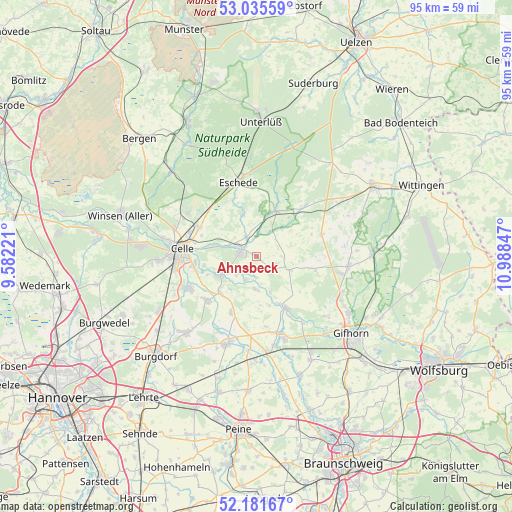
Ahnsbeck GPS coordinates[2]
52° 36' 38.556" North, 10° 17' 7.224" East
| Map corner | latitude | longitude |
|---|---|---|
| Upper-left | 53.03559°, | 9.58221° |
| Center: | 52.61071°, | 10.28534° |
| Lower-right: | 52.18167°, | 10.98847° |
| Map W x H: | 94.9×94.9 km | = 59×59mi |
| max Lat: | 55.01917° ⇑21.1% North |
| Ahnsbeck: | 52.61071° |
| min Lat: | ⇓78.9% South 47.40724° |
| min Long | Ahnsbeck | max Long |
| 5.92978° | 10.28534° | 14.98853° |
| W 55.1%⇐ | ⇒44.9% E |
Elevation
Elevation of Ahnsbeck is 54 m = 177 ft, and this is 195.1 m = 640 ft below average elevation for this country.
| Max E: |
1256 m = 4121 ft | 77.5% |
| Avg. | 249.1 m = 817 ft | |
| Ahnsbeck | 54 m = 177 ft | |
Min E: |
-5 m = -16 ft | 22.5% |
See also: Germany elevation on elevation.city.
Geographical zone
Ahnsbeck is located in North temperate zone (between Tropic of Cancer and the Arctic Circle). Distance of this North polar circle is 1551.4 km =964 mi to North.| Distance of | km | miles | from Ahnsbeck |
|---|---|---|---|
| North Pole | 4157.3 | 2583.2 | to North |
| Arctic Circle | 1551.4 | 964 | to North |
| Tropic Cancer | 3243.8 | 2015.6 | to South |
| Equator | 5849.8 | 3634.9 | to South |


Nearby cities:
15 places around Ahnsbeck: (largest is in red/bold)
• Beedenbostel
4 km =2.5 mi,  333°
333°
• Bröckel
11.5 km =7.1 mi,  204°
204°
• Eicklingen
9.6 km =6 mi,  225°
225°
• Eldingen
8.7 km =5.4 mi,  21°
21°
• Habighorst
11.6 km =7.2 mi,  340°
340°
• Hohne
6.7 km =4.2 mi,  113°
113°
• Höfer
8.4 km =5.2 mi, 343°
• Lachendorf
2.5 km =1.6 mi,  285°
285°
• Langlingen
6.1 km =3.8 mi,  181°
181°
• Müden
10.5 km =6.5 mi,  151°
151°
• Scharnhorst
11.8 km =7.3 mi,  359°
359°
• Steinhorst
11.2 km =7 mi,  43°
43°
• Ummern
10.1 km =6.3 mi,  102°
102°
• Wathlingen
12.3 km =7.6 mi, 227°
• Wienhausen
7.4 km =4.6 mi,  242°
242°
Sources, notices
• [Note1] Compared only with cities in Germany existing in our database
• [Src1] Map data: © OpenStreetMap contributors (CC-BY-SA)
• [Src2] Other city data from geonames.org with taken over terms of usage.
• [Src3] Geographical zone / Annual Mean Temperature by Robert A. Rohde @ Wikipedia
