Wathlingen geodata
Wathlingen (Lower Saxony) is a populated place; located in Germany in Europe/Berlin (GMT+2) time zone. With population of 6,431 people, there are 2322 cities with bigger population in this country. Compared to other cities in Germany, 77.9% of cities are located further ↓South; 52.5% of cities are located further ←West and 81% of cities have higher elevation than Wathlingen. Note1


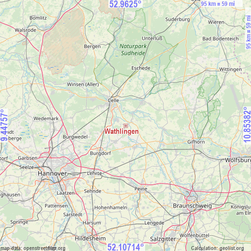
Wathlingen GPS coordinates[2]
52° 32' 12.84" North, 10° 9' 2.484" East
| Map corner | latitude | longitude |
|---|---|---|
| Upper-left | 52.9625°, | 9.44757° |
| Center: | 52.5369°, | 10.15069° |
| Lower-right: | 52.10714°, | 10.85382° |
| Map W x H: | 95.1×95.1 km | = 59.1×59.1mi |
| max Lat: | 55.01917° ⇑22.1% North |
| Wathlingen: | 52.5369° |
| min Lat: | ⇓77.9% South 47.40724° |
| min Long | Wathlingen | max Long |
| 5.92978° | 10.15069° | 14.98853° |
| W 52.5%⇐ | ⇒47.5% E |
Elevation
Elevation of Wathlingen is 44 m = 144 ft, and this is 205.1 m = 673 ft below average elevation for this country.
| Max E: |
1256 m = 4121 ft | 81% |
| Avg. | 249.1 m = 817 ft | |
| Wathlingen | 44 m = 144 ft | |
Min E: |
-5 m = -16 ft | 19% |
See also: Germany elevation on elevation.city.
Geographical zone
Wathlingen is located in North temperate zone (between Tropic of Cancer and the Arctic Circle). Distance of this North polar circle is 1559.6 km =969.1 mi to North.| Distance of | km | miles | from Wathlingen |
|---|---|---|---|
| North Pole | 4165.5 | 2588.3 | to North |
| Arctic Circle | 1559.6 | 969.1 | to North |
| Tropic Cancer | 3235.6 | 2010.5 | to South |
| Equator | 5841.6 | 3629.8 | to South |


Nearby cities:
15 places around Wathlingen: (largest is in red/bold)
• Adelheidsdorf
6.8 km =4.2 mi,  296°
296°
• Ahnsbeck
12.3 km =7.6 mi,  47°
47°
• Altmerdingsen
8.2 km =5.1 mi,  189°
189°
• Beedenbostel
13.9 km =8.6 mi,  31°
31°
• Bröckel
4.9 km =3 mi,  117°
117°
• Burgdorf
14 km =8.7 mi,  224°
224°
• Celle
10.6 km =6.6 mi,  333°
333°
• Eicklingen
2.7 km =1.7 mi,  56°
56°
• Hänigsen
7.1 km =4.4 mi,  214°
214°
• Lachendorf
11.1 km =6.9 mi,  37°
37°
• Langlingen
9.2 km =5.7 mi,  76°
76°
• Nienhagen
4 km =2.5 mi, 304°
• Schwüblingsen
13.9 km =8.6 mi,  183°
183°
• Uetze
8.8 km =5.5 mi,  155°
155°
• Wienhausen
5.5 km =3.4 mi, 28°
Sources, notices
• [Note1] Compared only with cities in Germany existing in our database
• [Src1] Map data: © OpenStreetMap contributors (CC-BY-SA)
• [Src2] Other city data from geonames.org with taken over terms of usage.
• [Src3] Geographical zone / Annual Mean Temperature by Robert A. Rohde @ Wikipedia
