Eicklingen geodata
Eicklingen (Lower Saxony) is a populated place; located in Germany in Europe/Berlin (GMT+2) time zone. With population of 3,292 people, there are 3757 cities with bigger population in this country. Compared to other cities in Germany, 78.1% of cities are located further ↓South; 53.1% of cities are located further ←West and 81.4% of cities have higher elevation than Eicklingen. Note1


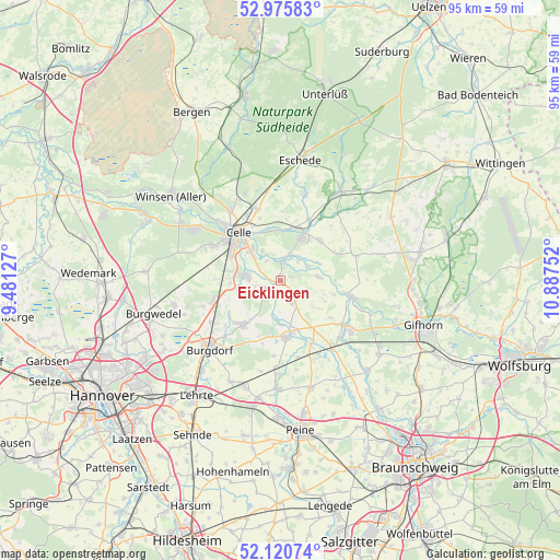
Eicklingen GPS coordinates[2]
52° 33' 1.332" North, 10° 11' 3.804" East
| Map corner | latitude | longitude |
|---|---|---|
| Upper-left | 52.97583°, | 9.48127° |
| Center: | 52.55037°, | 10.18439° |
| Lower-right: | 52.12074°, | 10.88752° |
| Map W x H: | 95.1×95.1 km | = 59.1×59.1mi |
| max Lat: | 55.01917° ⇑21.9% North |
| Eicklingen: | 52.55037° |
| min Lat: | ⇓78.1% South 47.40724° |
| min Long | Eicklingen | max Long |
| 5.92978° | 10.18439° | 14.98853° |
| W 53.1%⇐ | ⇒46.9% E |
Elevation
Elevation of Eicklingen is 43 m = 141 ft, and this is 206.1 m = 676 ft below average elevation for this country.
| Max E: |
1256 m = 4121 ft | 81.4% |
| Avg. | 249.1 m = 817 ft | |
| Eicklingen | 43 m = 141 ft | |
Min E: |
-5 m = -16 ft | 18.6% |
See also: Germany elevation on elevation.city.
Geographical zone
Eicklingen is located in North temperate zone (between Tropic of Cancer and the Arctic Circle). Distance of this North polar circle is 1558.1 km =968.2 mi to North.| Distance of | km | miles | from Eicklingen |
|---|---|---|---|
| North Pole | 4164 | 2587.4 | to North |
| Arctic Circle | 1558.1 | 968.2 | to North |
| Tropic Cancer | 3237.1 | 2011.4 | to South |
| Equator | 5843.1 | 3630.7 | to South |


Nearby cities:
15 places around Eicklingen: (largest is in red/bold)
• Adelheidsdorf
8.5 km =5.3 mi,  280°
280°
• Ahnsbeck
9.6 km =6 mi,  45°
45°
• Altmerdingsen
10.2 km =6.3 mi,  201°
201°
• Beedenbostel
11.5 km =7.1 mi,  26°
26°
• Bröckel
4.3 km =2.7 mi,  151°
151°
• Celle
10.7 km =6.6 mi,  318°
318°
• Hohne
13.6 km =8.5 mi,  72°
72°
• Hänigsen
9.7 km =6 mi,  220°
220°
• Lachendorf
8.6 km =5.3 mi, 31°
• Langlingen
6.7 km =4.2 mi,  84°
84°
• Müden
12.1 km =7.5 mi,  101°
101°
• Nienhagen
5.6 km =3.5 mi, 277°
• Uetze
9.6 km =6 mi,  171°
171°
• Wathlingen
2.7 km =1.7 mi,  236°
236°
• Wienhausen
3.3 km =2.1 mi,  4°
4°
Sources, notices
• [Note1] Compared only with cities in Germany existing in our database
• [Src1] Map data: © OpenStreetMap contributors (CC-BY-SA)
• [Src2] Other city data from geonames.org with taken over terms of usage.
• [Src3] Geographical zone / Annual Mean Temperature by Robert A. Rohde @ Wikipedia
