Beedenbostel geodata
Beedenbostel (Lower Saxony) is a seat of a fourth-order administrative division; located in Germany in Europe/Berlin (GMT+2) time zone. With population of 1,005 people, there are 7163 cities with bigger population in this country. Compared to other cities in Germany, 79.2% of cities are located further ↓South; 54.5% of cities are located further ←West and 77.9% of cities have higher elevation than Beedenbostel. Note1


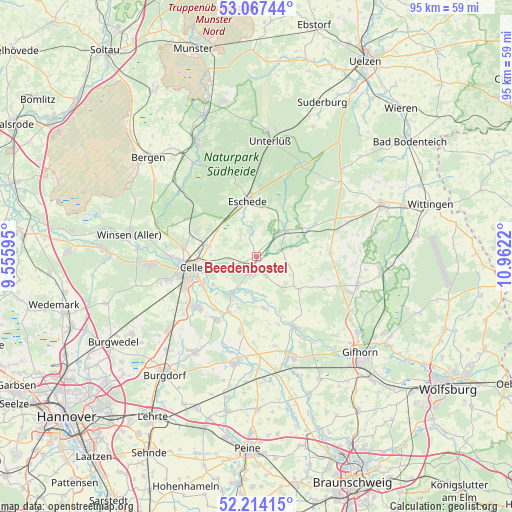
Beedenbostel GPS coordinates[2]
52° 38' 34.368" North, 10° 15' 32.652" East
| Map corner | latitude | longitude |
|---|---|---|
| Upper-left | 53.06744°, | 9.55595° |
| Center: | 52.64288°, | 10.25907° |
| Lower-right: | 52.21415°, | 10.9622° |
| Map W x H: | 94.9×94.9 km | = 59×59mi |
| max Lat: | 55.01917° ⇑20.8% North |
| Beedenbostel: | 52.64288° |
| min Lat: | ⇓79.2% South 47.40724° |
| min Long | Beedenbostel | max Long |
| 5.92978° | 10.25907° | 14.98853° |
| W 54.5%⇐ | ⇒45.5% E |
Elevation
Elevation of Beedenbostel is 53 m = 174 ft, and this is 196.1 m = 643 ft below average elevation for this country.
| Max E: |
1256 m = 4121 ft | 77.9% |
| Avg. | 249.1 m = 817 ft | |
| Beedenbostel | 53 m = 174 ft | |
Min E: |
-5 m = -16 ft | 22.1% |
See also: Germany elevation on elevation.city.
Geographical zone
Beedenbostel is located in North temperate zone (between Tropic of Cancer and the Arctic Circle). Distance of this North polar circle is 1547.8 km =961.8 mi to North.| Distance of | km | miles | from Beedenbostel |
|---|---|---|---|
| North Pole | 4153.7 | 2581 | to North |
| Arctic Circle | 1547.8 | 961.8 | to North |
| Tropic Cancer | 3247.4 | 2017.8 | to South |
| Equator | 5853.3 | 3637.1 | to South |


Nearby cities:
15 places around Beedenbostel: (largest is in red/bold)
• Ahnsbeck
4 km =2.5 mi,  153°
153°
• Celle
12.3 km =7.6 mi,  259°
259°
• Eicklingen
11.5 km =7.1 mi,  206°
206°
• Eldingen
6.7 km =4.2 mi,  48°
48°
• Eschede
10.4 km =6.5 mi,  351°
351°
• Groß Oesingen
13.8 km =8.6 mi,  87°
87°
• Habighorst
7.6 km =4.7 mi,  343°
343°
• Hohne
10 km =6.2 mi,  128°
128°
• Höfer
4.5 km =2.8 mi, 352°
• Lachendorf
3 km =1.9 mi,  191°
191°
• Langlingen
9.8 km =6.1 mi,  170°
170°
• Scharnhorst
8.4 km =5.2 mi,  11°
11°
• Steinhorst
10.5 km =6.5 mi,  64°
64°
• Ummern
13 km =8.1 mi,  116°
116°
• Wienhausen
8.4 km =5.2 mi, 214°
Sources, notices
• [Note1] Compared only with cities in Germany existing in our database
• [Src1] Map data: © OpenStreetMap contributors (CC-BY-SA)
• [Src2] Other city data from geonames.org with taken over terms of usage.
• [Src3] Geographical zone / Annual Mean Temperature by Robert A. Rohde @ Wikipedia
