Oppenweiler geodata
Oppenweiler (Baden-Württemberg) is a seat of a fourth-order administrative division; located in Germany in Europe/Berlin (GMT+2) time zone. With population of 4,295 people, there are 3133 cities with bigger population in this country. Compared to other cities in Germany, 83.2% of cities are located further ↑North; 58.5% of cities are located further →East and 55.8% of cities have lower elevation than Oppenweiler. Note1
Administrative division(s):
- Level 1: Baden-Württemberg
- Level 2: Regierungsbezirk Stuttgart
- Level 3: Rems-Murr-Kreis
- Level 4: Oppenweiler


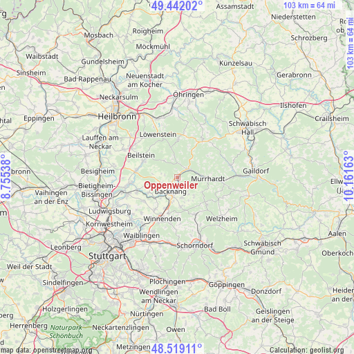
Oppenweiler GPS coordinates[2]
48° 58' 57.72" North, 9° 27' 30.6" East
| Map corner | latitude | longitude |
|---|---|---|
| Upper-left | 49.44202°, | 8.75538° |
| Center: | 48.9827°, | 9.4585° |
| Lower-right: | 48.51911°, | 10.16163° |
| Map W x H: | 102.6×102.6 km | = 63.8×63.8mi |
| max Lat: | 55.01917° ⇑83.2% North |
| Oppenweiler: | 48.9827° |
| min Lat: | ⇓16.8% South 47.40724° |
| min Long | Oppenweiler | max Long |
| 5.92978° | 9.4585° | 14.98853° |
| W 41.5%⇐ | ⇒58.5% E |
Elevation
Elevation of Oppenweiler is 264 m = 866 ft, and this is 14.9 m = 49 ft above average elevation for this country.
| Max E: |
1256 m = 4121 ft | 44.2% |
| Oppenweiler | 264 m 866 ft | |
| Avg. | 249.1 m = 817 ft | |
Min E: |
-5 m = -16 ft | 55.8% |
See also: Germany elevation on elevation.city.
Geographical zone
Oppenweiler is located in North temperate zone (between Tropic of Cancer and the Arctic Circle). Distance of this North polar circle is 1954.8 km =1214.7 mi to North.| Distance of | km | miles | from Oppenweiler |
|---|---|---|---|
| North Pole | 4560.7 | 2833.9 | to North |
| Arctic Circle | 1954.8 | 1214.7 | to North |
| Tropic Cancer | 2840.4 | 1764.9 | to South |
| Equator | 5446.4 | 3384.2 | to South |


Nearby cities:
15 places around Oppenweiler: (largest is in red/bold)
• Affalterbach
11.9 km =7.4 mi,  235°
235°
• Allmersbach im Tal
8.5 km =5.3 mi,  175°
175°
• Althütte
11 km =6.8 mi,  132°
132°
• Aspach
4.6 km =2.9 mi,  247°
247°
• Backnang
4.2 km =2.6 mi,  201°
201°
• Burgstetten
8.7 km =5.4 mi,  225°
225°
• Großerlach
8.9 km =5.5 mi,  26°
26°
• Kirchberg an der Murr
9.7 km =6 mi, 242°
• Leutenbach
11.6 km =7.2 mi, 204°
• Mittelschöntal
6.2 km =3.9 mi, 228°
• Murrhardt
8.2 km =5.1 mi,  90°
90°
• Oberstenfeld
11.1 km =6.9 mi,  295°
295°
• Spiegelberg
6.5 km =4 mi,  350°
350°
• Sulzbach an der Murr
3.8 km =2.4 mi,  53°
53°
• Wüstenrot
10.9 km =6.8 mi,  0°
0°
Sources, notices
• [Note1] Compared only with cities in Germany existing in our database
• [Src1] Map data: © OpenStreetMap contributors (CC-BY-SA)
• [Src2] Other city data from geonames.org with taken over terms of usage.
• [Src3] Geographical zone / Annual Mean Temperature by Robert A. Rohde @ Wikipedia
