Häuslingen geodata
Häuslingen (Lower Saxony) is a seat of a fourth-order administrative division; located in Germany in Europe/Berlin (GMT+2) time zone. With population of 858 people, there are 7673 cities with bigger population in this country. Compared to other cities in Germany, 80.5% of cities are located further ↓South; 59.4% of cities are located further →East and 90.1% of cities have higher elevation than Häuslingen. Note1


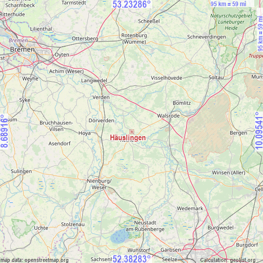
Häuslingen GPS coordinates[2]
52° 48' 35.712" North, 9° 23' 32.208" East
| Map corner | latitude | longitude |
|---|---|---|
| Upper-left | 53.23286°, | 8.68916° |
| Center: | 52.80992°, | 9.39228° |
| Lower-right: | 52.38283°, | 10.09541° |
| Map W x H: | 94.5×94.5 km | = 58.7×58.7mi |
| max Lat: | 55.01917° ⇑19.5% North |
| Häuslingen: | 52.80992° |
| min Lat: | ⇓80.5% South 47.40724° |
| min Long | Häuslingen | max Long |
| 5.92978° | 9.39228° | 14.98853° |
| W 40.6%⇐ | ⇒59.4% E |
Elevation
Elevation of Häuslingen is 21 m = 69 ft, and this is 228.1 m = 748 ft below average elevation for this country.
| Max E: |
1256 m = 4121 ft | 90.1% |
| Avg. | 249.1 m = 817 ft | |
| Häuslingen | 21 m = 69 ft | |
Min E: |
-5 m = -16 ft | 9.9% |
See also: Germany elevation on elevation.city.
Geographical zone
Häuslingen is located in North temperate zone (between Tropic of Cancer and the Arctic Circle). Distance of this North polar circle is 1529.3 km =950.3 mi to North.| Distance of | km | miles | from Häuslingen |
|---|---|---|---|
| North Pole | 4135.1 | 2569.4 | to North |
| Arctic Circle | 1529.3 | 950.3 | to North |
| Tropic Cancer | 3266 | 2029.4 | to South |
| Equator | 5871.9 | 3648.6 | to South |


Nearby cities:
15 places around Häuslingen: (largest is in red/bold)
• Ahlden
12.1 km =7.5 mi,  117°
117°
• Böhme
5.8 km =3.6 mi, 120°
• Dörverden
11.6 km =7.2 mi,  292°
292°
• Eystrup
12.5 km =7.8 mi,  254°
254°
• Frankenfeld
5.3 km =3.3 mi,  151°
151°
• Gandesbergen
12.5 km =7.8 mi,  243°
243°
• Grethem
15.2 km =9.4 mi,  127°
127°
• Haßbergen
13.7 km =8.5 mi,  231°
231°
• Heemsen
14.9 km =9.3 mi,  214°
214°
• Hodenhagen
14.5 km =9 mi,  110°
110°
• Hämelhausen
8 km =5 mi, 246°
• Kirchlinteln
15.5 km =9.6 mi,  341°
341°
• Rethem
2.8 km =1.7 mi,  199°
199°
• Röhrsen
15.5 km =9.6 mi,  224°
224°
• Walsrode
14.6 km =9.1 mi,  66°
66°
Sources, notices
• [Note1] Compared only with cities in Germany existing in our database
• [Src1] Map data: © OpenStreetMap contributors (CC-BY-SA)
• [Src2] Other city data from geonames.org with taken over terms of usage.
• [Src3] Geographical zone / Annual Mean Temperature by Robert A. Rohde @ Wikipedia
