Lautertal geodata
Lautertal (Bavaria) is a seat of a fourth-order administrative division; located in Germany in Europe/Berlin (GMT+2) time zone. With population of 4,150 people, there are 3196 cities with bigger population in this country. Compared to other cities in Germany, 56.1% of cities are located further ↑North; 66.4% of cities are located further ←West and 80.1% of cities have lower elevation than Lautertal. Note1
Administrative division(s):
- Level 1: Bavaria
- Level 2: Upper Franconia
- Level 3: Landkreis Coburg
- Level 4: Lautertal


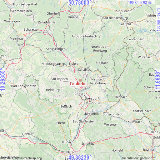
Lautertal GPS coordinates[2]
50° 19' 59.988" North, 10° 58' 0.012" East
| Map corner | latitude | longitude |
|---|---|---|
| Upper-left | 50.78003°, | 10.26355° |
| Center: | 50.33333°, | 10.96667° |
| Lower-right: | 49.88239°, | 11.6698° |
| Map W x H: | 99.8×99.8 km | = 62×62mi |
| max Lat: | 55.01917° ⇑56.1% North |
| Lautertal: | 50.33333° |
| min Lat: | ⇓43.9% South 47.40724° |
| min Long | Lautertal | max Long |
| 5.92978° | 10.96667° | 14.98853° |
| W 66.4%⇐ | ⇒33.6% E |
Elevation
Elevation of Lautertal is 433 m = 1421 ft, and this is 183.9 m = 603 ft above average elevation for this country.
| Max E: |
1256 m = 4121 ft | 19.9% |
| Lautertal | 433 m 1421 ft | |
| Avg. | 249.1 m = 817 ft | |
Min E: |
-5 m = -16 ft | 80.1% |
See also: Germany elevation on elevation.city.
Geographical zone
Lautertal is located in North temperate zone (between Tropic of Cancer and the Arctic Circle). Distance of this North polar circle is 1804.6 km =1121.3 mi to North.| Distance of | km | miles | from Lautertal |
|---|---|---|---|
| North Pole | 4410.5 | 2740.6 | to North |
| Arctic Circle | 1804.6 | 1121.3 | to North |
| Tropic Cancer | 2990.6 | 1858.3 | to South |
| Equator | 5596.5 | 3477.5 | to South |


Nearby cities:
15 places around Lautertal: (largest is in red/bold)
• Ahorn
10.7 km =6.6 mi,  184°
184°
• Bachfeld
9.3 km =5.8 mi,  7°
7°
• Bockstadt
9.5 km =5.9 mi,  321°
321°
• Coburg
8.2 km =5.1 mi, 181°
• Ebersdorf
13.2 km =8.2 mi,  92°
92°
• Eisfeld
11.2 km =7 mi,  337°
337°
• Meeder
4.4 km =2.7 mi,  252°
252°
• Mengersgereuth-Hämmern
12.8 km =8 mi,  56°
56°
• Neustadt bei Coburg
10.9 km =6.8 mi, 92°
• Niederfüllbach
12.7 km =7.9 mi,  172°
172°
• Rödental
6.8 km =4.2 mi,  128°
128°
• Sachsenbrunn
12.7 km =7.9 mi,  354°
354°
• Schalkau
7.5 km =4.7 mi,  22°
22°
• Ummerstadt
13.8 km =8.6 mi,  232°
232°
• Weitramsdorf
10.6 km =6.6 mi,  215°
215°
Sources, notices
• [Note1] Compared only with cities in Germany existing in our database
• [Src1] Map data: © OpenStreetMap contributors (CC-BY-SA)
• [Src2] Other city data from geonames.org with taken over terms of usage.
• [Src3] Geographical zone / Annual Mean Temperature by Robert A. Rohde @ Wikipedia
