Leinfelden-Echterdingen geodata
Leinfelden-Echterdingen (Baden-Württemberg) is a populated place; located in Germany in Europe/Berlin (GMT+2) time zone. With population of 36,672 people, there are 362 cities with bigger population in this country. Compared to other cities in Germany, 86.5% of cities are located further ↑North; 62.9% of cities are located further →East and 78.3% of cities have lower elevation than Leinfelden-Echterdingen. Note1
Administrative division(s):
- Level 1: Baden-Württemberg
- Level 2: Regierungsbezirk Stuttgart
- Level 3: Landkreis Esslingen
- Level 4: Leinfelden-Echterdingen
Current local time in Leinfelden-Echterdingen:
11:50 AM, TuesdayDifference from your time zone: hours


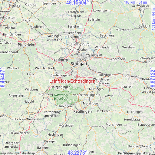
Leinfelden-Echterdingen GPS coordinates[2]
48° 41' 38.616" North, 9° 10' 5.124" East
| Map corner | latitude | longitude |
|---|---|---|
| Upper-left | 49.15604°, | 8.46497° |
| Center: | 48.69406°, | 9.16809° |
| Lower-right: | 48.2278°, | 9.87122° |
| Map W x H: | 103.2×103.2 km | = 64.1×64.1mi |
| max Lat: | 55.01917° ⇑86.5% North |
| Leinfelden-Echterdingen: | 48.69406° |
| min Lat: | ⇓13.5% South 47.40724° |
| min Long | Leinfelden-Echt | max Long |
| 5.92978° | 9.16809° | 14.98853° |
| W 37.1%⇐ | ⇒62.9% E |
Elevation
Elevation of Leinfelden-Echterdingen is 422 m = 1385 ft, and this is 172.9 m = 567 ft above average elevation for this country.
| Max E: |
1256 m = 4121 ft | 21.7% |
| Leinfelden-Echterdingen | 422 m 1385 ft | |
| Avg. | 249.1 m = 817 ft | |
Min E: |
-5 m = -16 ft | 78.3% |
See also: Germany elevation on elevation.city.
Geographical zone
Leinfelden-Echterdingen is located in North temperate zone (between Tropic of Cancer and the Arctic Circle). Distance of this North polar circle is 1986.9 km =1234.6 mi to North.| Distance of | km | miles | from Leinfelden-Echterdingen |
|---|---|---|---|
| North Pole | 4592.8 | 2853.8 | to North |
| Arctic Circle | 1986.9 | 1234.6 | to North |
| Tropic Cancer | 2808.4 | 1745.1 | to South |
| Equator | 5414.3 | 3364.3 | to South |


Nearby cities:
15 places around Leinfelden-Echterdingen: (largest is in red/bold)
• Denkendorf
10.9 km =6.8 mi,  89°
89°
• Dettenhausen
10.8 km =6.7 mi,  207°
207°
• Esslingen
11.2 km =7 mi,  63°
63°
• Filderstadt
5.6 km =3.5 mi,  136°
136°
• Neuhausen auf den Fildern
8.5 km =5.3 mi,  98°
98°
• Ostfildern
7 km =4.3 mi, 58°
• Schlaitdorf
10.8 km =6.7 mi,  158°
158°
• Schönaich
8.8 km =5.5 mi,  243°
243°
• Sindelfingen
11.1 km =6.9 mi,  273°
273°
• Steinenbronn
4.9 km =3 mi,  231°
231°
• Stuttgart
9.8 km =6.1 mi,  3°
3°
• Stuttgart-Ost
10.4 km =6.5 mi,  17°
17°
• Waldenbuch
6.7 km =4.2 mi,  202°
202°
• Weil im Schönbuch
11 km =6.8 mi,  224°
224°
• Wolfschlugen
9.8 km =6.1 mi,  120°
120°
Sources, notices
• [Note1] Compared only with cities in Germany existing in our database
• [Src1] Map data: © OpenStreetMap contributors (CC-BY-SA)
• [Src2] Other city data from geonames.org with taken over terms of usage.
• [Src3] Geographical zone / Annual Mean Temperature by Robert A. Rohde @ Wikipedia
