Dallgow-Döberitz geodata
Dallgow-Döberitz (Brandenburg) is a populated place; located in Germany in Europe/Berlin (GMT+2) time zone. With population of 7,439 people, there are 2086 cities with bigger population in this country. Compared to other cities in Germany, 78% of cities are located further ↓South; 92.7% of cities are located further ←West and 84.9% of cities have higher elevation than Dallgow-Döberitz. Note1
Administrative division(s):
- Level 1: Brandenburg
- Level 3: Landkreis Havelland
- Level 4: Dallgow-Döberitz


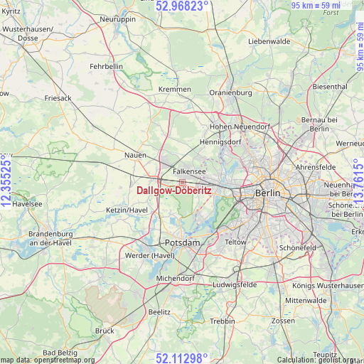
Dallgow-Döberitz GPS coordinates[2]
52° 32' 33.684" North, 13° 3' 30.132" East
| Map corner | latitude | longitude |
|---|---|---|
| Upper-left | 52.96823°, | 12.35525° |
| Center: | 52.54269°, | 13.05837° |
| Lower-right: | 52.11298°, | 13.7615° |
| Map W x H: | 95.1×95.1 km | = 59.1×59.1mi |
| max Lat: | 55.01917° ⇑22% North |
| Dallgow-Döberitz: | 52.54269° |
| min Lat: | ⇓78% South 47.40724° |
| min Long | Dallgow-Döberi | max Long |
| 5.92978° | 13.05837° | 14.98853° |
| W 92.7%⇐ | ⇒7.3% E |
Elevation
Elevation of Dallgow-Döberitz is 35 m = 115 ft, and this is 214.1 m = 702 ft below average elevation for this country.
| Max E: |
1256 m = 4121 ft | 84.9% |
| Avg. | 249.1 m = 817 ft | |
| Dallgow-Döberitz | 35 m = 115 ft | |
Min E: |
-5 m = -16 ft | 15.1% |
See also: Germany elevation on elevation.city.
Geographical zone
Dallgow-Döberitz is located in North temperate zone (between Tropic of Cancer and the Arctic Circle). Distance of this North polar circle is 1559 km =968.7 mi to North.| Distance of | km | miles | from Dallgow-Döberitz |
|---|---|---|---|
| North Pole | 4164.9 | 2587.9 | to North |
| Arctic Circle | 1559 | 968.7 | to North |
| Tropic Cancer | 3236.3 | 2010.9 | to South |
| Equator | 5842.2 | 3630.2 | to South |


Nearby cities:
15 places around Dallgow-Döberitz: (largest is in red/bold)
• Brieselang
6 km =3.7 mi,  318°
318°
• Falkenhagener Feld
7.5 km =4.7 mi,  82°
82°
• Falkensee
3 km =1.9 mi,  50°
50°
• Gatow
10.7 km =6.6 mi,  128°
128°
• Hakenfelde
10.3 km =6.4 mi, 79°
• Haselhorst
12.1 km =7.5 mi,  89°
89°
• Hennigsdorf
14.3 km =8.9 mi,  43°
43°
• Kladow
11.4 km =7.1 mi,  149°
149°
• Konradshöhe
12.4 km =7.7 mi,  67°
67°
• Nauen
14.4 km =8.9 mi,  299°
299°
• Siemensstadt
13.8 km =8.6 mi, 90°
• Spandau
9.6 km =6 mi, 84°
• Staaken
6.3 km =3.9 mi,  96°
96°
• Wilhelmstadt
8.3 km =5.2 mi, 104°
• Wustermark
7.4 km =4.6 mi,  276°
276°
Sources, notices
• [Note1] Compared only with cities in Germany existing in our database
• [Src1] Map data: © OpenStreetMap contributors (CC-BY-SA)
• [Src2] Other city data from geonames.org with taken over terms of usage.
• [Src3] Geographical zone / Annual Mean Temperature by Robert A. Rohde @ Wikipedia
