Hennigsdorf geodata
Hennigsdorf (Brandenburg) is a populated place; located in Germany in Europe/Berlin (GMT+2) time zone. With population of 26,122 people, there are 556 cities with bigger population in this country. Compared to other cities in Germany, 79.2% of cities are located further ↓South; 93.7% of cities are located further ←West and 85.8% of cities have higher elevation than Hennigsdorf. Note1


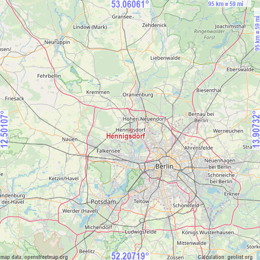
Hennigsdorf GPS coordinates[2]
52° 38' 9.528" North, 13° 12' 15.084" East
| Map corner | latitude | longitude |
|---|---|---|
| Upper-left | 53.06061°, | 12.50107° |
| Center: | 52.63598°, | 13.20419° |
| Lower-right: | 52.20719°, | 13.90732° |
| Map W x H: | 94.9×94.9 km | = 59×59mi |
| max Lat: | 55.01917° ⇑20.8% North |
| Hennigsdorf: | 52.63598° |
| min Lat: | ⇓79.2% South 47.40724° |
| min Long | Hennigsdorf | max Long |
| 5.92978° | 13.20419° | 14.98853° |
| W 93.7%⇐ | ⇒6.3% E |
Elevation
Elevation of Hennigsdorf is 33 m = 108 ft, and this is 216.1 m = 709 ft below average elevation for this country.
| Max E: |
1256 m = 4121 ft | 85.8% |
| Avg. | 249.1 m = 817 ft | |
| Hennigsdorf | 33 m = 108 ft | |
Min E: |
-5 m = -16 ft | 14.2% |
See also: Germany elevation on elevation.city.
Geographical zone
Hennigsdorf is located in North temperate zone (between Tropic of Cancer and the Arctic Circle). Distance of this North polar circle is 1548.6 km =962.3 mi to North.| Distance of | km | miles | from Hennigsdorf |
|---|---|---|---|
| North Pole | 4154.5 | 2581.5 | to North |
| Arctic Circle | 1548.6 | 962.3 | to North |
| Tropic Cancer | 3246.7 | 2017.4 | to South |
| Equator | 5852.6 | 3636.6 | to South |


Nearby cities:
15 places around Hennigsdorf: (largest is in red/bold)
• Birkenwerder
7.5 km =4.7 mi,  45°
45°
• Falkenhagener Feld
9.7 km =6 mi,  194°
194°
• Frohnau
5.8 km =3.6 mi,  92°
92°
• Glienicke
8.2 km =5.1 mi, 91°
• Hakenfelde
8.6 km =5.3 mi,  178°
178°
• Heiligensee
3.6 km =2.2 mi,  130°
130°
• Hermsdorf
7.3 km =4.5 mi,  109°
109°
• Hohen Neuendorf
6.7 km =4.2 mi, 47°
• Konradshöhe
5.8 km =3.6 mi,  164°
164°
• Leegebruch
9.7 km =6 mi,  355°
355°
• Spandau
9.4 km =5.8 mi, 182°
• Tegel
9 km =5.6 mi,  137°
137°
• Velten
6.5 km =4 mi,  342°
342°
• Waidmannslust
8.4 km =5.2 mi, 112°
• Wittenau
9.2 km =5.7 mi,  121°
121°
Sources, notices
• [Note1] Compared only with cities in Germany existing in our database
• [Src1] Map data: © OpenStreetMap contributors (CC-BY-SA)
• [Src2] Other city data from geonames.org with taken over terms of usage.
• [Src3] Geographical zone / Annual Mean Temperature by Robert A. Rohde @ Wikipedia
