Bad Vilbel geodata
Bad Vilbel (Hesse) is a populated place; located in Germany in Europe/Berlin (GMT+2) time zone. With population of 30,736 people, there are 452 cities with bigger population in this country. Compared to other cities in Germany, 59.5% of cities are located further ↑North; 68.7% of cities are located further →East and 65.6% of cities have higher elevation than Bad Vilbel. Note1
Administrative division(s):
- Level 1: Hesse
- Level 2: Regierungsbezirk Darmstadt
- Level 3: Wetteraukreis
- Level 4: Bad Vilbel


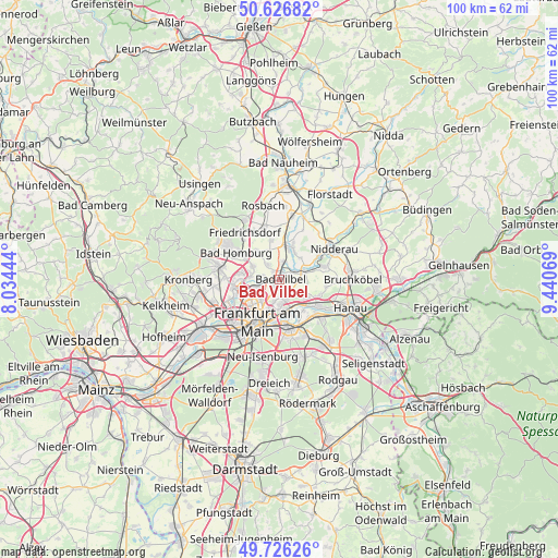
Bad Vilbel GPS coordinates[2]
50° 10' 43.176" North, 8° 44' 15.216" East
| Map corner | latitude | longitude |
|---|---|---|
| Upper-left | 50.62682°, | 8.03444° |
| Center: | 50.17866°, | 8.73756° |
| Lower-right: | 49.72626°, | 9.44069° |
| Map W x H: | 100.1×100.1 km | = 62.2×62.2mi |
| max Lat: | 55.01917° ⇑59.5% North |
| Bad Vilbel: | 50.17866° |
| min Lat: | ⇓40.5% South 47.40724° |
| min Long | Bad Vilbel | max Long |
| 5.92978° | 8.73756° | 14.98853° |
| W 31.3%⇐ | ⇒68.7% E |
Elevation
Elevation of Bad Vilbel is 117 m = 384 ft, and this is 132.1 m = 433 ft below average elevation for this country.
| Max E: |
1256 m = 4121 ft | 65.6% |
| Avg. | 249.1 m = 817 ft | |
| Bad Vilbel | 117 m = 384 ft | |
Min E: |
-5 m = -16 ft | 34.4% |
See also: Germany elevation on elevation.city.
Geographical zone
Bad Vilbel is located in North temperate zone (between Tropic of Cancer and the Arctic Circle). Distance of this North polar circle is 1821.8 km =1132 mi to North.| Distance of | km | miles | from Bad Vilbel |
|---|---|---|---|
| North Pole | 4427.7 | 2751.2 | to North |
| Arctic Circle | 1821.8 | 1132 | to North |
| Tropic Cancer | 2973.4 | 1847.6 | to South |
| Equator | 5579.3 | 3466.8 | to South |


Nearby cities:
15 places around Bad Vilbel: (largest is in red/bold)
• Bad Homburg vor der Höhe
10 km =6.2 mi,  302°
302°
• Bruchköbel
13.2 km =8.2 mi,  90°
90°
• Eschborn
12.5 km =7.8 mi,  251°
251°
• Frankfurt am Main
8 km =5 mi,  208°
208°
• Friedrichsdorf
10.4 km =6.5 mi,  319°
319°
• Gallus
11.6 km =7.2 mi,  221°
221°
• Karben
6.2 km =3.9 mi,  22°
22°
• Maintal
7.5 km =4.7 mi,  115°
115°
• Mühlheim am Main
9.7 km =6 mi,  135°
135°
• Nidderau
11.3 km =7 mi,  54°
54°
• Niederdorfelden
4.8 km =3 mi,  68°
68°
• Niederrad
13.2 km =8.2 mi, 216°
• Oberursel
11.8 km =7.3 mi,  285°
285°
• Offenbach
8.9 km =5.5 mi,  166°
166°
• Steinbach am Taunus
11.8 km =7.3 mi,  264°
264°
Sources, notices
• [Note1] Compared only with cities in Germany existing in our database
• [Src1] Map data: © OpenStreetMap contributors (CC-BY-SA)
• [Src2] Other city data from geonames.org with taken over terms of usage.
• [Src3] Geographical zone / Annual Mean Temperature by Robert A. Rohde @ Wikipedia
