Albertstadt geodata
Albertstadt (Saxony) is a populated place; located in Germany in Europe/Berlin (GMT+2) time zone. With population of 2,137 people, there are 4884 cities with bigger population in this country. Compared to other cities in Germany, 59.5% of cities are located further ↓South; 97.2% of cities are located further ←West and 60.6% of cities have higher elevation than Albertstadt. Note1


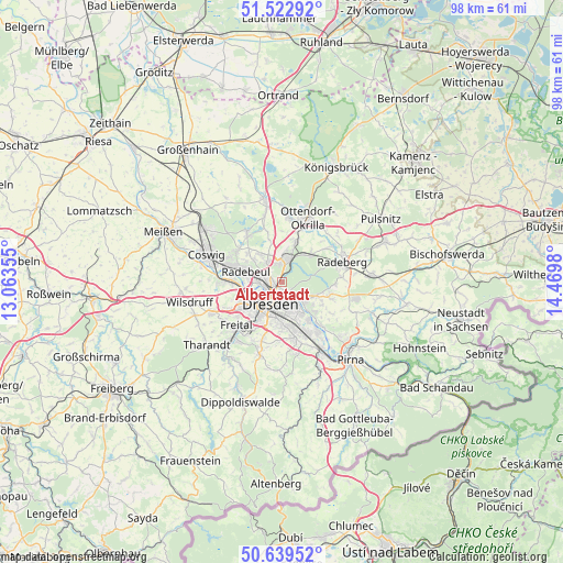
Albertstadt GPS coordinates[2]
51° 4' 59.988" North, 13° 46' 0.012" East
| Map corner | latitude | longitude |
|---|---|---|
| Upper-left | 51.52292°, | 13.06355° |
| Center: | 51.08333°, | 13.76667° |
| Lower-right: | 50.63952°, | 14.4698° |
| Map W x H: | 98.2×98.2 km | = 61×61mi |
| max Lat: | 55.01917° ⇑40.5% North |
| Albertstadt: | 51.08333° |
| min Lat: | ⇓59.5% South 47.40724° |
| min Long | Albertstadt | max Long |
| 5.92978° | 13.76667° | 14.98853° |
| W 97.2%⇐ | ⇒2.8% E |
Elevation
Elevation of Albertstadt is 148 m = 486 ft, and this is 101.1 m = 332 ft below average elevation for this country.
| Max E: |
1256 m = 4121 ft | 60.6% |
| Avg. | 249.1 m = 817 ft | |
| Albertstadt | 148 m = 486 ft | |
Min E: |
-5 m = -16 ft | 39.4% |
See also: Germany elevation on elevation.city.
Geographical zone
Albertstadt is located in North temperate zone (between Tropic of Cancer and the Arctic Circle). Distance of this North polar circle is 1721.2 km =1069.5 mi to North.| Distance of | km | miles | from Albertstadt |
|---|---|---|---|
| North Pole | 4327.1 | 2688.7 | to North |
| Arctic Circle | 1721.2 | 1069.5 | to North |
| Tropic Cancer | 3074 | 1910.1 | to South |
| Equator | 5679.9 | 3529.3 | to South |


Nearby cities:
15 places around Albertstadt: (largest is in red/bold)
• Arnsdorf
15.8 km =9.8 mi,  85°
85°
• Bannewitz
10.6 km =6.6 mi,  199°
199°
• Coswig
13.9 km =8.6 mi,  292°
292°
• Dohna
15.5 km =9.6 mi,  155°
155°
• Dresden
4.1 km =2.5 mi,  208°
208°
• Feldschlößchen
12.1 km =7.5 mi,  59°
59°
• Freital
12.3 km =7.6 mi,  222°
222°
• Heidenau
14.2 km =8.8 mi,  150°
150°
• Kreischa
15.4 km =9.6 mi,  183°
183°
• Moritzburg
10.4 km =6.5 mi,  324°
324°
• Ottendorf-Okrilla
12.1 km =7.5 mi,  22°
22°
• Radeberg
10.6 km =6.6 mi,  73°
73°
• Radebeul
7.9 km =4.9 mi, 289°
• Radeburg
14.9 km =9.3 mi,  349°
349°
• Wachau
13.1 km =8.1 mi,  48°
48°
Sources, notices
• [Note1] Compared only with cities in Germany existing in our database
• [Src1] Map data: © OpenStreetMap contributors (CC-BY-SA)
• [Src2] Other city data from geonames.org with taken over terms of usage.
• [Src3] Geographical zone / Annual Mean Temperature by Robert A. Rohde @ Wikipedia
