Tadjourah geodata
Tadjourah is a seat of a first-order administrative division; located in Djibouti in Africa/Djibouti (GMT+3) time zone. With population of 22,193 people, there are 2 cities with bigger population in this country. Compared to other cities in Djibouti, 75% of cities are located further ↓South; 58.3% of cities are located further →East and 83.3% of cities have higher elevation than Tadjourah. Note1


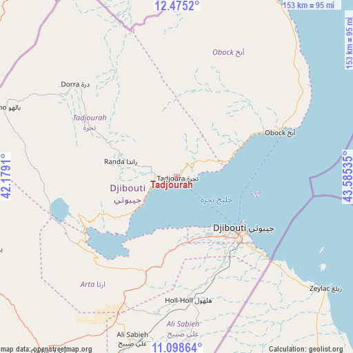
Tadjourah GPS coordinates[2]
11° 47' 16.008" North, 42° 52' 55.992" East
| Map corner | latitude | longitude |
|---|---|---|
| Upper-left | 12.4752°, | 42.1791° |
| Center: | 11.78778°, | 42.88222° |
| Lower-right: | 11.09864°, | 43.58535° |
| Map W x H: | 153.1×153.1 km | = 95.1×95.1mi |
| max Lat: | 12.42167° ⇑25% North |
| Tadjourah: | 11.78778° |
| min Lat: | ⇓75% South 11.10454° |
| min Long | Tadjourah | max Long |
| 41.83611° | 42.88222° | 43.28835° |
| W 41.7%⇐ | ⇒58.3% E |
Elevation
Elevation of Tadjourah is 21 m = 69 ft, and this is 255.8 m = 839 ft below average elevation for this country.
| Max E: |
706 m = 2316 ft | 83.3% |
| Avg. | 276.8 m = 908 ft | |
| Tadjourah | 21 m = 69 ft | |
Min E: |
6 m = 20 ft | 16.7% |
See also: Djibouti elevation on elevation.city.
Geographical zone
Tadjourah is located in North Torrid zone (between Equator and Tropic of Cancer). Distance of this Northern Tropic circle is 1295.2 km =804.8 mi to North.| Distance of | km | miles | from Tadjourah |
|---|---|---|---|
| North Pole | 8696.4 | 5403.7 | to North |
| Arctic Circle | 6090.5 | 3784.5 | to North |
| Tropic Cancer | 1295.2 | 804.8 | to North |
| Equator | 1310.7 | 814.4 | to South |


Nearby cities:
12 places around Tadjourah: (largest is in red/bold)
• 'Ali Sabieh
72.7 km =45.2 mi,  194°
194°
• Alaïli Ḏaḏḏa‘
70.5 km =43.8 mi,  1°
1°
• Arta
29.3 km =18.2 mi, 186°
• Chabelley
39.3 km =24.4 mi,  147°
147°
• Dikhil
94.3 km =58.6 mi,  216°
216°
• Djibouti
36.2 km =22.5 mi,  127°
127°
• Dorra
59.8 km =37.2 mi,  312°
312°
• Goubétto
42.5 km =26.4 mi,  162°
162°
• Gâlâfi
114.2 km =71 mi,  265°
265°
• Holhol
53.3 km =33.1 mi,  174°
174°
• Loyada
54.3 km =33.7 mi, 131°
• Obock
48.5 km =30.1 mi,  65°
65°
Sources, notices
• [Note1] Compared only with cities in Djibouti existing in our database
• [Src1] Map data: © OpenStreetMap contributors (CC-BY-SA)
• [Src2] Other city data from geonames.org with taken over terms of usage.
• [Src3] Geographical zone / Annual Mean Temperature by Robert A. Rohde @ Wikipedia
