Goubétto geodata
Goubétto (Ali Sabieh) is a populated place; located in Djibouti in Africa/Djibouti (GMT+3) time zone. With population of 2,003 people, there are 7 cities with bigger population in this country. Compared to other cities in Djibouti, 75% of cities are located further ↑North; 66.7% of cities are located further ←West and 58.3% of cities have lower elevation than Goubétto. Note1


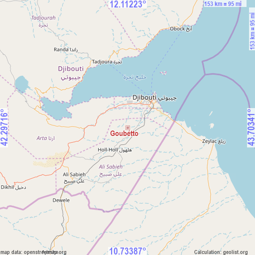
Goubétto GPS coordinates[2]
11° 25' 26.004" North, 43° 0' 1.008" East
| Map corner | latitude | longitude |
|---|---|---|
| Upper-left | 12.11223°, | 42.29716° |
| Center: | 11.42389°, | 43.00028° |
| Lower-right: | 10.73387°, | 43.70341° |
| Map W x H: | 153.3×153.3 km | = 95.3×95.3mi |
| max Lat: | 12.42167° ⇑75% North |
| Goubétto: | 11.42389° |
| min Lat: | ⇓25% South 11.10454° |
| min Long | Goubétto | max Long |
| 41.83611° | 43.00028° | 43.28835° |
| W 66.7%⇐ | ⇒33.3% E |
Elevation
Elevation of Goubétto is 342 m = 1122 ft, and this is 65.2 m = 214 ft above average elevation for this country.
| Max E: |
706 m = 2316 ft | 41.7% |
| Goubétto | 342 m 1122 ft | |
| Avg. | 276.8 m = 908 ft | |
Min E: |
6 m = 20 ft | 58.3% |
See also: Djibouti elevation on elevation.city.
Geographical zone
Goubétto is located in North Torrid zone (between Equator and Tropic of Cancer). Distance of Equator is 1270.2 km =789.3 mi to South.| Distance of | km | miles | from Goubétto |
|---|---|---|---|
| North Pole | 8736.8 | 5428.8 | to North |
| Arctic Circle | 6131 | 3809.6 | to North |
| Tropic Cancer | 1335.7 | 830 | to North |
| Equator | 1270.2 | 789.3 | to South |


Nearby cities:
12 places around Goubétto: (largest is in red/bold)
• 'Ali Sabieh
43.3 km =26.9 mi,  226°
226°
• Alaïli Ḏaḏḏa‘
111.5 km =69.3 mi,  354°
354°
• Arta
19.8 km =12.3 mi,  305°
305°
• Chabelley
11 km =6.8 mi,  48°
48°
• Dikhil
77.4 km =48.1 mi,  242°
242°
• Djibouti
24.2 km =15 mi,  40°
40°
• Dorra
98.9 km =61.5 mi,  324°
324°
• Gâlâfi
130.9 km =81.3 mi,  284°
284°
• Holhol
14.8 km =9.2 mi,  211°
211°
• Loyada
27.8 km =17.3 mi,  81°
81°
• Obock
68 km =42.3 mi,  27°
27°
• Tadjourah
42.5 km =26.4 mi,  342°
342°
Sources, notices
• [Note1] Compared only with cities in Djibouti existing in our database
• [Src1] Map data: © OpenStreetMap contributors (CC-BY-SA)
• [Src2] Other city data from geonames.org with taken over terms of usage.
• [Src3] Geographical zone / Annual Mean Temperature by Robert A. Rohde @ Wikipedia
