Alaïli Ḏaḏḏa‘ geodata
Alaïli Ḏaḏḏa‘ (Obock) is a populated place; located in Djibouti in Africa/Djibouti (GMT+3) time zone. With population of 1,456 people, there are 11 cities with bigger population in this country. Compared to other cities in Djibouti, 100% of cities are located further ↓South; 50% of cities are located further ←West and 66.7% of cities have lower elevation than Alaïli Ḏaḏḏa‘. Note1


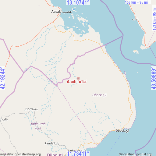
Alaïli Ḏaḏḏa‘ GPS coordinates[2]
12° 25' 18.012" North, 42° 53' 44.016" East
| Map corner | latitude | longitude |
|---|---|---|
| Upper-left | 13.10741°, | 42.19244° |
| Center: | 12.42167°, | 42.89556° |
| Lower-right: | 11.73411°, | 43.59869° |
| Map W x H: | 152.7×152.7 km | = 94.9×94.9mi |
| max Lat: | 12.42167° ⇑0% North |
| Alaïli Ḏaḏḏa‘: | 12.42167° |
| min Lat: | ⇓100% South 11.10454° |
| min Long | Alaïli Ḏaḏ | max Long |
| 41.83611° | 42.89556° | 43.28835° |
| W 50%⇐ | ⇒50% E |
Elevation
Elevation of Alaïli Ḏaḏḏa‘ is 357 m = 1171 ft, and this is 80.2 m = 263 ft above average elevation for this country.
| Max E: |
706 m = 2316 ft | 33.3% |
| Alaïli Ḏaḏḏa‘ | 357 m 1171 ft | |
| Avg. | 276.8 m = 908 ft | |
Min E: |
6 m = 20 ft | 66.7% |
See also: Djibouti elevation on elevation.city.
Geographical zone
Alaïli Ḏaḏḏa‘ is located in North Torrid zone (between Equator and Tropic of Cancer). Distance of this Northern Tropic circle is 1224.8 km =761.1 mi to North.| Distance of | km | miles | from Alaïli Ḏaḏḏa‘ |
|---|---|---|---|
| North Pole | 8625.9 | 5359.9 | to North |
| Arctic Circle | 6020 | 3740.7 | to North |
| Tropic Cancer | 1224.8 | 761.1 | to North |
| Equator | 1381.2 | 858.2 | to South |


Nearby cities:
12 places around Alaïli Ḏaḏḏa‘: (largest is in red/bold)
• 'Ali Sabieh
142.2 km =88.4 mi,  188°
188°
• Arta
99.7 km =62 mi,  182°
182°
• Chabelley
105.5 km =65.6 mi,  169°
169°
• Dikhil
157.2 km =97.7 mi,  201°
201°
• Djibouti
96.5 km =60 mi,  163°
163°
• Dorra
54.6 km =33.9 mi,  236°
236°
• Goubétto
111.5 km =69.3 mi, 174°
• Gâlâfi
139.4 km =86.6 mi, 235°
• Holhol
123.6 km =76.8 mi, 178°
• Loyada
113.7 km =70.6 mi, 160°
• Obock
66.2 km =41.1 mi,  139°
139°
• Tadjourah
70.5 km =43.8 mi, 181°
Sources, notices
• [Note1] Compared only with cities in Djibouti existing in our database
• [Src1] Map data: © OpenStreetMap contributors (CC-BY-SA)
• [Src2] Other city data from geonames.org with taken over terms of usage.
• [Src3] Geographical zone / Annual Mean Temperature by Robert A. Rohde @ Wikipedia
