'Ali Sabieh geodata
'Ali Sabieh (Ali Sabieh) is a seat of a first-order administrative division; located in Djibouti in Africa/Djibouti (GMT+3) time zone. With population of 55,000 people, there is 1 city with bigger population in this country. Compared to other cities in Djibouti, 91.7% of cities are located further ↑North; 75% of cities are located further →East and 91.7% of cities have lower elevation than 'Ali Sabieh. Note1


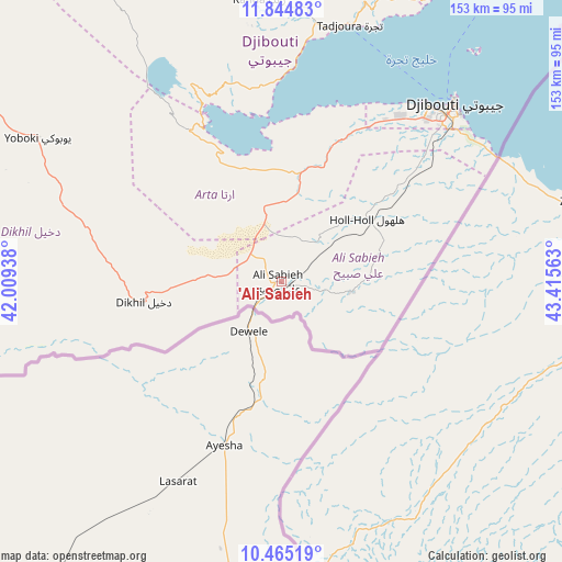
'Ali Sabieh GPS coordinates[2]
11° 9' 20.988" North, 42° 42' 45" East
| Map corner | latitude | longitude |
|---|---|---|
| Upper-left | 11.84483°, | 42.00938° |
| Center: | 11.15583°, | 42.7125° |
| Lower-right: | 10.46519°, | 43.41563° |
| Map W x H: | 153.4×153.4 km | = 95.3×95.3mi |
| max Lat: | 12.42167° ⇑91.7% North |
| 'Ali Sabieh: | 11.15583° |
| min Lat: | ⇓8.3% South 11.10454° |
| min Long | 'Ali Sabieh | max Long |
| 41.83611° | 42.7125° | 43.28835° |
| W 25%⇐ | ⇒75% E |
Elevation
Elevation of 'Ali Sabieh is 699 m = 2293 ft, and this is 422.2 m = 1385 ft above average elevation for this country.
| Max E: |
706 m = 2316 ft | 8.3% |
| 'Ali Sabieh | 699 m 2293 ft | |
| Avg. | 276.8 m = 908 ft | |
Min E: |
6 m = 20 ft | 91.7% |
See also: 'Ali Sabieh elevation on elevation.city.
Geographical zone
'Ali Sabieh is located in North Torrid zone (between Equator and Tropic of Cancer). Distance of Equator is 1240.4 km =770.7 mi to South.| Distance of | km | miles | from 'Ali Sabieh |
|---|---|---|---|
| North Pole | 8766.6 | 5447.3 | to North |
| Arctic Circle | 6160.8 | 3828.1 | to North |
| Tropic Cancer | 1365.5 | 848.5 | to North |
| Equator | 1240.4 | 770.7 | to South |


Nearby cities:
12 places around 'Ali Sabieh: (largest is in red/bold)
• Alaïli Ḏaḏḏa‘
142.2 km =88.4 mi,  8°
8°
• Arta
43.9 km =27.3 mi,  20°
20°
• Chabelley
54.2 km =33.7 mi,  46°
46°
• Dikhil
37.8 km =23.5 mi,  261°
261°
• Djibouti
67.4 km =41.9 mi,  44°
44°
• Dorra
113.5 km =70.5 mi,  346°
346°
• Goubétto
43.3 km =26.9 mi, 46°
• Gâlâfi
114 km =70.8 mi,  303°
303°
• Holhol
29.2 km =18.1 mi, 54°
• Loyada
68 km =42.3 mi,  60°
60°
• Obock
109.9 km =68.3 mi,  34°
34°
• Tadjourah
72.7 km =45.2 mi, 14°
Sources, notices
• [Note1] Compared only with cities in Djibouti existing in our database
• [Src1] Map data: © OpenStreetMap contributors (CC-BY-SA)
• [Src2] Other city data from geonames.org with taken over terms of usage.
• [Src3] Geographical zone / Annual Mean Temperature by Robert A. Rohde @ Wikipedia
