Loyada geodata
Loyada (Djibouti) is a populated place; located in Djibouti in Africa/Djibouti (GMT+3) time zone. With population of 1,646 people, there are 10 cities with bigger population in this country. Compared to other cities in Djibouti, 66.7% of cities are located further ↑North; 91.7% of cities are located further ←West and 91.7% of cities have higher elevation than Loyada. Note1


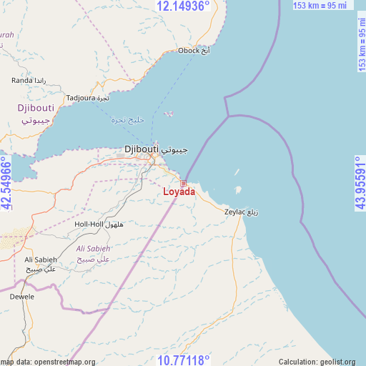
Loyada GPS coordinates[2]
11° 27' 39.996" North, 43° 15' 10.008" East
| Map corner | latitude | longitude |
|---|---|---|
| Upper-left | 12.14936°, | 42.54966° |
| Center: | 11.46111°, | 43.25278° |
| Lower-right: | 10.77118°, | 43.95591° |
| Map W x H: | 153.2×153.2 km | = 95.2×95.2mi |
| max Lat: | 12.42167° ⇑66.7% North |
| Loyada: | 11.46111° |
| min Lat: | ⇓33.3% South 11.10454° |
| min Long | Loyada | max Long |
| 41.83611° | 43.25278° | 43.28835° |
| W 91.7%⇐ | ⇒8.3% E |
Elevation
Elevation of Loyada is 7 m = 23 ft, and this is 269.8 m = 885 ft below average elevation for this country.
| Max E: |
706 m = 2316 ft | 91.7% |
| Avg. | 276.8 m = 908 ft | |
| Loyada | 7 m = 23 ft | |
Min E: |
6 m = 20 ft | 8.3% |
See also: Djibouti elevation on elevation.city.
Geographical zone
Loyada is located in North Torrid zone (between Equator and Tropic of Cancer). Distance of Equator is 1274.4 km =791.9 mi to South.| Distance of | km | miles | from Loyada |
|---|---|---|---|
| North Pole | 8732.7 | 5426.2 | to North |
| Arctic Circle | 6126.8 | 3807 | to North |
| Tropic Cancer | 1331.6 | 827.4 | to North |
| Equator | 1274.4 | 791.9 | to South |


Nearby cities:
12 places around Loyada: (largest is in red/bold)
• 'Ali Sabieh
68 km =42.3 mi,  240°
240°
• Alaïli Ḏaḏḏa‘
113.7 km =70.6 mi,  340°
340°
• Arta
44.3 km =27.5 mi,  279°
279°
• Chabelley
19.6 km =12.2 mi, 279°
• Dikhil
104.1 km =64.7 mi,  247°
247°
• Djibouti
18.4 km =11.4 mi,  320°
320°
• Dorra
114.1 km =70.9 mi,  312°
312°
• Goubétto
27.8 km =17.3 mi,  261°
261°
• Gâlâfi
156.9 km =97.5 mi, 280°
• Holhol
39 km =24.2 mi, 244°
• Obock
56.4 km =35 mi,  3°
3°
• Tadjourah
54.3 km =33.7 mi, 311°
Sources, notices
• [Note1] Compared only with cities in Djibouti existing in our database
• [Src1] Map data: © OpenStreetMap contributors (CC-BY-SA)
• [Src2] Other city data from geonames.org with taken over terms of usage.
• [Src3] Geographical zone / Annual Mean Temperature by Robert A. Rohde @ Wikipedia
