Djibouti geodata
Djibouti is a capital of a political entity; located in Djibouti in Africa/Djibouti (GMT+3) time zone. With population of 623,891 people, there are 0 cities with bigger population in this country. Compared to other cities in Djibouti, 58.3% of cities are located further ↓South; 83.3% of cities are located further ←West and 100% of cities have higher elevation than Djibouti. Note1


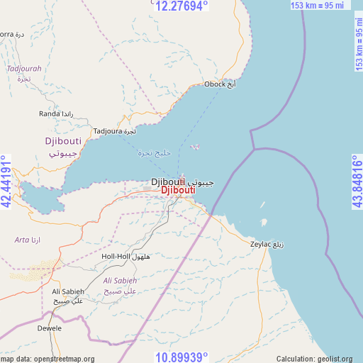
Djibouti GPS coordinates[2]
11° 35' 20.436" North, 43° 8' 42.108" East
| Map corner | latitude | longitude |
|---|---|---|
| Upper-left | 12.27694°, | 42.44191° |
| Center: | 11.58901°, | 43.14503° |
| Lower-right: | 10.89939°, | 43.84816° |
| Map W x H: | 153.2×153.2 km | = 95.2×95.2mi |
| max Lat: | 12.42167° ⇑41.7% North |
| Djibouti: | 11.58901° |
| min Lat: | ⇓58.3% South 11.10454° |
| min Long | Djibouti | max Long |
| 41.83611° | 43.14503° | 43.28835° |
| W 83.3%⇐ | ⇒16.7% E |
Elevation
Elevation of Djibouti is 6 m = 20 ft, and this is 270.8 m = 888 ft below average elevation for this country.
| Max E: |
706 m = 2316 ft | 100% |
| Avg. | 276.8 m = 908 ft | |
| Djibouti | 6 m = 20 ft | |
Min E: |
6 m = 20 ft | 0% |
See also: Djibouti elevation on elevation.city.
Geographical zone
Djibouti is located in North Torrid zone (between Equator and Tropic of Cancer). Distance of Equator is 1288.6 km =800.7 mi to South.| Distance of | km | miles | from Djibouti |
|---|---|---|---|
| North Pole | 8718.5 | 5417.4 | to North |
| Arctic Circle | 6112.6 | 3798.2 | to North |
| Tropic Cancer | 1317.3 | 818.5 | to North |
| Equator | 1288.6 | 800.7 | to South |


Nearby cities:
12 places around Djibouti: (largest is in red/bold)
• 'Ali Sabieh
67.4 km =41.9 mi,  224°
224°
• Alaïli Ḏaḏḏa‘
96.5 km =60 mi,  343°
343°
• Arta
32.7 km =20.3 mi,  257°
257°
• Chabelley
13.4 km =8.3 mi,  214°
214°
• Dikhil
100.2 km =62.3 mi,  237°
237°
• Dorra
95.9 km =59.6 mi,  310°
310°
• Goubétto
24.2 km =15 mi, 220°
• Gâlâfi
143.2 km =89 mi,  275°
275°
• Holhol
38.9 km =24.2 mi, 217°
• Loyada
18.4 km =11.4 mi,  140°
140°
• Obock
44.8 km =27.8 mi,  20°
20°
• Tadjourah
36.2 km =22.5 mi, 307°
In other languages:
- In Spanish: Yibuti
- In German: Dschibuti
- In Italian: Gibuti
- In Russian: Джибути
- In Chinese: 吉布地市
Sources, notices
• [Note1] Compared only with cities in Djibouti existing in our database
• [Src1] Map data: © OpenStreetMap contributors (CC-BY-SA)
• [Src2] Other city data from geonames.org with taken over terms of usage.
• [Src3] Geographical zone / Annual Mean Temperature by Robert A. Rohde @ Wikipedia
