Vejle geodata
Vejle (South Denmark) is a seat of a first-order administrative division; located in Denmark in Europe/Copenhagen (GMT+2) time zone. With population of 51,177 people, there are 9 cities with bigger population in this country. Compared to other cities in Denmark, 52% of cities are located further ↑North; 77.8% of cities are located further →East and 89.8% of cities have higher elevation than Vejle. Note1


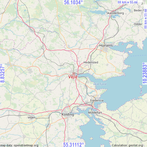
Vejle GPS coordinates[2]
55° 42' 33.372" North, 9° 32' 8.52" East
| Map corner | latitude | longitude |
|---|---|---|
| Upper-left | 56.1034°, | 8.83257° |
| Center: | 55.70927°, | 9.5357° |
| Lower-right: | 55.31112°, | 10.23883° |
| Map W x H: | 88.1×88.1 km | = 54.7×54.7mi |
| max Lat: | 57.72093° ⇑52% North |
| Vejle: | 55.70927° |
| min Lat: | ⇓48% South 54.57644° |
| min Long | Vejle | max Long |
| 8.12605° | 9.5357° | 15.18662° |
| W 22.2%⇐ | ⇒77.8% E |
Elevation
Elevation of Vejle is 5 m = 16 ft, and this is 22.3 m = 73 ft below average elevation for this country.
| Max E: |
114 m = 374 ft | 89.8% |
| Avg. | 27.3 m = 90 ft | |
| Vejle | 5 m = 16 ft | |
Min E: |
0 m = 0 ft | 10.2% |
See also: Vejle elevation on elevation.city.
Geographical zone
Vejle is located in North temperate zone (between Tropic of Cancer and the Arctic Circle). Distance of this North polar circle is 1206.9 km =749.9 mi to North.| Distance of | km | miles | from Vejle |
|---|---|---|---|
| North Pole | 3812.8 | 2369.2 | to North |
| Arctic Circle | 1206.9 | 749.9 | to North |
| Tropic Cancer | 3588.4 | 2229.7 | to South |
| Equator | 6194.3 | 3849 | to South |


Nearby cities:
15 places around Vejle: (largest is in red/bold)
• Brejning
9.8 km =6.1 mi,  119°
119°
• Børkop
10.3 km =6.4 mi,  136°
136°
• Egtved
17.7 km =11 mi,  234°
234°
• Fredericia
21 km =13 mi, 139°
• Give
24 km =14.9 mi,  309°
309°
• Hedensted
12.4 km =7.7 mi,  56°
56°
• Hornsyld
20.7 km =12.9 mi,  75°
75°
• Horsens
25.9 km =16.1 mi,  49°
49°
• Jelling
8.6 km =5.3 mi, 306°
• Kolding
24.7 km =15.3 mi,  189°
189°
• Middelfart
25.7 km =16 mi,  151°
151°
• Snoghøj
23.8 km =14.8 mi, 150°
• Strib
23.8 km =14.8 mi, 142°
• Taulov
18.9 km =11.7 mi,  164°
164°
• Tørring
16 km =9.9 mi,  348°
348°
Sources, notices
• [Note1] Compared only with cities in Denmark existing in our database
• [Src1] Map data: © OpenStreetMap contributors (CC-BY-SA)
• [Src2] Other city data from geonames.org with taken over terms of usage.
• [Src3] Geographical zone / Annual Mean Temperature by Robert A. Rohde @ Wikipedia
