Give geodata
Give (South Denmark) is a populated place; located in Denmark in Europe/Copenhagen (GMT+2) time zone. With population of 4,240 people, there are 151 cities with bigger population in this country. Compared to other cities in Denmark, 57.6% of cities are located further ↓South; 85.4% of cities are located further →East and 98.5% of cities have lower elevation than Give. Note1


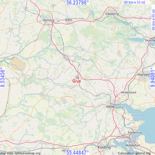
Give GPS coordinates[2]
55° 50' 42.828" North, 9° 14' 15.684" East
| Map corner | latitude | longitude |
|---|---|---|
| Upper-left | 56.23798°, | 8.53456° |
| Center: | 55.84523°, | 9.23769° |
| Lower-right: | 55.44847°, | 9.94081° |
| Map W x H: | 87.8×87.8 km | = 54.6×54.6mi |
| max Lat: | 57.72093° ⇑42.4% North |
| Give: | 55.84523° |
| min Lat: | ⇓57.6% South 54.57644° |
| min Long | Give | max Long |
| 8.12605° | 9.23769° | 15.18662° |
| W 14.6%⇐ | ⇒85.4% E |
Elevation
Elevation of Give is 88 m = 289 ft, and this is 60.7 m = 199 ft above average elevation for this country.
| Max E: |
114 m = 374 ft | 1.5% |
| Give | 88 m 289 ft | |
| Avg. | 27.3 m = 90 ft | |
Min E: |
0 m = 0 ft | 98.5% |
See also: Denmark elevation on elevation.city.
Geographical zone
Give is located in North temperate zone (between Tropic of Cancer and the Arctic Circle). Distance of this North polar circle is 1191.8 km =740.5 mi to North.| Distance of | km | miles | from Give |
|---|---|---|---|
| North Pole | 3797.7 | 2359.8 | to North |
| Arctic Circle | 1191.8 | 740.5 | to North |
| Tropic Cancer | 3603.5 | 2239.1 | to South |
| Equator | 6209.4 | 3858.3 | to South |


Nearby cities:
15 places around Give: (largest is in red/bold)
• Billund
14.8 km =9.2 mi,  213°
213°
• Brande
12.9 km =8 mi,  327°
327°
• Brejning
33.7 km =20.9 mi,  126°
126°
• Brædstrup
27.2 km =16.9 mi,  58°
58°
• Egtved
25.8 km =16 mi,  170°
170°
• Grindsted
21.7 km =13.5 mi,  243°
243°
• Hammerum
33.9 km =21.1 mi,  341°
341°
• Hedensted
30.1 km =18.7 mi,  106°
106°
• Ikast
33 km =20.5 mi,  351°
351°
• Isenvad
28.3 km =17.6 mi,  355°
355°
• Jelling
15.4 km =9.6 mi, 130°
• Kibæk
31.5 km =19.6 mi,  311°
311°
• Lind
33.2 km =20.6 mi, 330°
• Tørring
15.3 km =9.5 mi,  88°
88°
• Vejle
24 km =14.9 mi, 129°
Sources, notices
• [Note1] Compared only with cities in Denmark existing in our database
• [Src1] Map data: © OpenStreetMap contributors (CC-BY-SA)
• [Src2] Other city data from geonames.org with taken over terms of usage.
• [Src3] Geographical zone / Annual Mean Temperature by Robert A. Rohde @ Wikipedia
