Kolding geodata
Kolding (South Denmark) is a seat of a second-order administrative division; located in Denmark in Europe/Copenhagen (GMT+2) time zone. With population of 55,363 people, there are 8 cities with bigger population in this country. Compared to other cities in Denmark, 67.8% of cities are located further ↑North; 80.1% of cities are located further →East and 83.3% of cities have higher elevation than Kolding. Note1


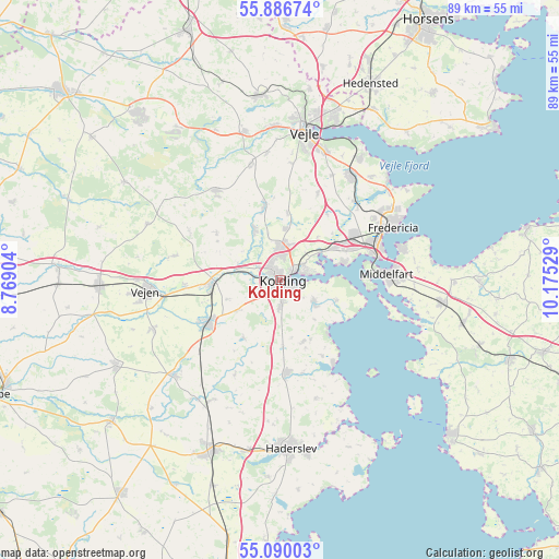
Kolding GPS coordinates[2]
55° 29' 25.44" North, 9° 28' 19.776" East
| Map corner | latitude | longitude |
|---|---|---|
| Upper-left | 55.88674°, | 8.76904° |
| Center: | 55.4904°, | 9.47216° |
| Lower-right: | 55.09003°, | 10.17529° |
| Map W x H: | 88.6×88.6 km | = 55.1×55.1mi |
| max Lat: | 57.72093° ⇑67.8% North |
| Kolding: | 55.4904° |
| min Lat: | ⇓32.2% South 54.57644° |
| min Long | Kolding | max Long |
| 8.12605° | 9.47216° | 15.18662° |
| W 19.9%⇐ | ⇒80.1% E |
Elevation
Elevation of Kolding is 8 m = 26 ft, and this is 19.3 m = 63 ft below average elevation for this country.
| Max E: |
114 m = 374 ft | 83.3% |
| Avg. | 27.3 m = 90 ft | |
| Kolding | 8 m = 26 ft | |
Min E: |
0 m = 0 ft | 16.7% |
See also: Kolding elevation on elevation.city.
Geographical zone
Kolding is located in North temperate zone (between Tropic of Cancer and the Arctic Circle). Distance of this North polar circle is 1231.2 km =765 mi to North.| Distance of | km | miles | from Kolding |
|---|---|---|---|
| North Pole | 3837.1 | 2384.3 | to North |
| Arctic Circle | 1231.2 | 765 | to North |
| Tropic Cancer | 3564 | 2214.6 | to South |
| Equator | 6170 | 3833.9 | to South |


Nearby cities:
15 places around Kolding: (largest is in red/bold)
• Brejning
23.2 km =14.4 mi,  32°
32°
• Børkop
20.2 km =12.6 mi, 33°
• Christiansfeld
14.7 km =9.1 mi,  176°
176°
• Egtved
17.4 km =10.8 mi,  323°
323°
• Fredericia
19.5 km =12.1 mi,  64°
64°
• Lunderskov
10.9 km =6.8 mi,  266°
266°
• Middelfart
16.4 km =10.2 mi,  83°
83°
• Nørre Åby
25.9 km =16.1 mi,  97°
97°
• Snoghøj
16.1 km =10 mi, 77°
• Strib
19.4 km =12.1 mi,  73°
73°
• Sønder Bjert
7.3 km =4.5 mi,  124°
124°
• Taulov
10.9 km =6.8 mi, 55°
• Vamdrup
13.7 km =8.5 mi,  239°
239°
• Vejen
21.1 km =13.1 mi, 267°
• Vejle
24.7 km =15.3 mi,  9°
9°
Sources, notices
• [Note1] Compared only with cities in Denmark existing in our database
• [Src1] Map data: © OpenStreetMap contributors (CC-BY-SA)
• [Src2] Other city data from geonames.org with taken over terms of usage.
• [Src3] Geographical zone / Annual Mean Temperature by Robert A. Rohde @ Wikipedia
