Brejning geodata
Brejning (South Denmark) is a populated place; located in Denmark in Europe/Copenhagen (GMT+2) time zone. With population of 2,220 people, there are 280 cities with bigger population in this country. Compared to other cities in Denmark, 55.6% of cities are located further ↑North; 74.3% of cities are located further →East and 82.2% of cities have lower elevation than Brejning. Note1


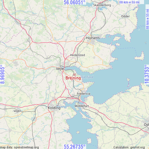
Brejning GPS coordinates[2]
55° 39' 57.384" North, 9° 40' 19.812" East
| Map corner | latitude | longitude |
|---|---|---|
| Upper-left | 56.06051°, | 8.96905° |
| Center: | 55.66594°, | 9.67217° |
| Lower-right: | 55.26735°, | 10.3753° |
| Map W x H: | 88.2×88.2 km | = 54.8×54.8mi |
| max Lat: | 57.72093° ⇑55.6% North |
| Brejning: | 55.66594° |
| min Lat: | ⇓44.4% South 54.57644° |
| min Long | Brejning | max Long |
| 8.12605° | 9.67217° | 15.18662° |
| W 25.7%⇐ | ⇒74.3% E |
Elevation
Elevation of Brejning is 48 m = 157 ft, and this is 20.7 m = 68 ft above average elevation for this country.
| Max E: |
114 m = 374 ft | 17.8% |
| Brejning | 48 m 157 ft | |
| Avg. | 27.3 m = 90 ft | |
Min E: |
0 m = 0 ft | 82.2% |
See also: Denmark elevation on elevation.city.
Geographical zone
Brejning is located in North temperate zone (between Tropic of Cancer and the Arctic Circle). Distance of this North polar circle is 1211.7 km =752.9 mi to North.| Distance of | km | miles | from Brejning |
|---|---|---|---|
| North Pole | 3817.6 | 2372.1 | to North |
| Arctic Circle | 1211.7 | 752.9 | to North |
| Tropic Cancer | 3583.6 | 2226.7 | to South |
| Equator | 6189.5 | 3846 | to South |


Nearby cities:
15 places around Brejning: (largest is in red/bold)
• Børkop
3 km =1.9 mi,  207°
207°
• Egtved
23.5 km =14.6 mi,  256°
256°
• Fredericia
12.2 km =7.6 mi,  155°
155°
• Hedensted
11.8 km =7.3 mi,  8°
8°
• Hornsyld
15.3 km =9.5 mi,  48°
48°
• Horsens
24.4 km =15.2 mi,  27°
27°
• Jelling
18.4 km =11.4 mi,  302°
302°
• Juelsminde
22.1 km =13.7 mi,  77°
77°
• Kolding
23.2 km =14.4 mi, 212°
• Middelfart
18.2 km =11.3 mi,  168°
168°
• Snoghøj
16.2 km =10.1 mi, 169°
• Strib
15.2 km =9.4 mi, 156°
• Taulov
13.8 km =8.6 mi,  194°
194°
• Tørring
23.6 km =14.7 mi,  330°
330°
• Vejle
9.8 km =6.1 mi, 299°
Sources, notices
• [Note1] Compared only with cities in Denmark existing in our database
• [Src1] Map data: © OpenStreetMap contributors (CC-BY-SA)
• [Src2] Other city data from geonames.org with taken over terms of usage.
• [Src3] Geographical zone / Annual Mean Temperature by Robert A. Rohde @ Wikipedia
