Børkop geodata
Børkop (South Denmark) is a populated place; located in Denmark in Europe/Copenhagen (GMT+2) time zone. With population of 3,561 people, there are 179 cities with bigger population in this country. Compared to other cities in Denmark, 57.9% of cities are located further ↑North; 75.1% of cities are located further →East and 54.1% of cities have lower elevation than Børkop. Note1


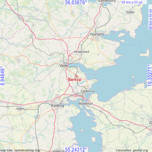
Børkop GPS coordinates[2]
55° 38' 31.02" North, 9° 38' 58.488" East
| Map corner | latitude | longitude |
|---|---|---|
| Upper-left | 56.03676°, | 8.94646° |
| Center: | 55.64195°, | 9.64958° |
| Lower-right: | 55.24312°, | 10.35271° |
| Map W x H: | 88.2×88.2 km | = 54.8×54.8mi |
| max Lat: | 57.72093° ⇑57.9% North |
| Børkop: | 55.64195° |
| min Lat: | ⇓42.1% South 54.57644° |
| min Long | Børkop | max Long |
| 8.12605° | 9.64958° | 15.18662° |
| W 24.9%⇐ | ⇒75.1% E |
Elevation
Elevation of Børkop is 25 m = 82 ft, and this is 2.3 m = 8 ft below average elevation for this country.
| Max E: |
114 m = 374 ft | 45.9% |
| Avg. | 27.3 m = 90 ft | |
| Børkop | 25 m = 82 ft | |
Min E: |
0 m = 0 ft | 54.1% |
See also: Denmark elevation on elevation.city.
Geographical zone
Børkop is located in North temperate zone (between Tropic of Cancer and the Arctic Circle). Distance of this North polar circle is 1214.4 km =754.6 mi to North.| Distance of | km | miles | from Børkop |
|---|---|---|---|
| North Pole | 3820.3 | 2373.8 | to North |
| Arctic Circle | 1214.4 | 754.6 | to North |
| Tropic Cancer | 3580.9 | 2225.1 | to South |
| Equator | 6186.8 | 3844.3 | to South |


Nearby cities:
15 places around Børkop: (largest is in red/bold)
• Brejning
3 km =1.9 mi,  27°
27°
• Egtved
21.7 km =13.5 mi,  262°
262°
• Fredericia
10.7 km =6.6 mi,  142°
142°
• Hedensted
14.6 km =9.1 mi,  12°
12°
• Hornsyld
18.1 km =11.2 mi,  45°
45°
• Jelling
18.9 km =11.7 mi,  312°
312°
• Juelsminde
24.2 km =15 mi,  72°
72°
• Kolding
20.2 km =12.6 mi,  213°
213°
• Middelfart
16 km =9.9 mi,  161°
161°
• Nørre Åby
24.8 km =15.4 mi, 144°
• Snoghøj
14 km =8.7 mi, 161°
• Strib
13.5 km =8.4 mi,  146°
146°
• Sønder Bjert
21.7 km =13.5 mi,  193°
193°
• Taulov
10.9 km =6.8 mi, 191°
• Vejle
10.3 km =6.4 mi,  316°
316°
Sources, notices
• [Note1] Compared only with cities in Denmark existing in our database
• [Src1] Map data: © OpenStreetMap contributors (CC-BY-SA)
• [Src2] Other city data from geonames.org with taken over terms of usage.
• [Src3] Geographical zone / Annual Mean Temperature by Robert A. Rohde @ Wikipedia
