Fredericia geodata
Fredericia (South Denmark) is a seat of a second-order administrative division; located in Denmark in Europe/Copenhagen (GMT+2) time zone. With population of 36,946 people, there are 19 cities with bigger population in this country. Compared to other cities in Denmark, 62.9% of cities are located further ↑North; 71.3% of cities are located further →East and 59.6% of cities have higher elevation than Fredericia. Note1


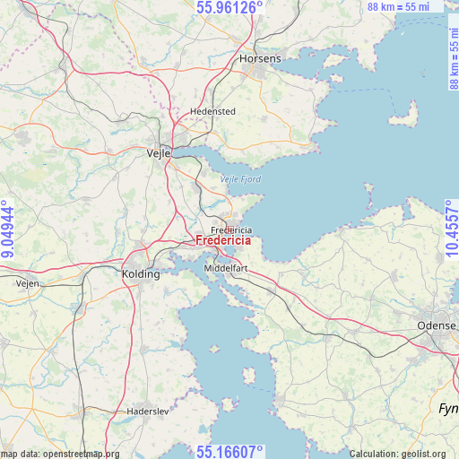
Fredericia GPS coordinates[2]
55° 33' 56.448" North, 9° 45' 9.252" East
| Map corner | latitude | longitude |
|---|---|---|
| Upper-left | 55.96126°, | 9.04944° |
| Center: | 55.56568°, | 9.75257° |
| Lower-right: | 55.16607°, | 10.4557° |
| Map W x H: | 88.4×88.4 km | = 54.9×54.9mi |
| max Lat: | 57.72093° ⇑62.9% North |
| Fredericia: | 55.56568° |
| min Lat: | ⇓37.1% South 54.57644° |
| min Long | Fredericia | max Long |
| 8.12605° | 9.75257° | 15.18662° |
| W 28.7%⇐ | ⇒71.3% E |
Elevation
Elevation of Fredericia is 16 m = 52 ft, and this is 11.3 m = 37 ft below average elevation for this country.
| Max E: |
114 m = 374 ft | 59.6% |
| Avg. | 27.3 m = 90 ft | |
| Fredericia | 16 m = 52 ft | |
Min E: |
0 m = 0 ft | 40.4% |
See also: Denmark elevation on elevation.city.
Geographical zone
Fredericia is located in North temperate zone (between Tropic of Cancer and the Arctic Circle). Distance of this North polar circle is 1222.8 km =759.8 mi to North.| Distance of | km | miles | from Fredericia |
|---|---|---|---|
| North Pole | 3828.7 | 2379 | to North |
| Arctic Circle | 1222.8 | 759.8 | to North |
| Tropic Cancer | 3572.4 | 2219.8 | to South |
| Equator | 6178.3 | 3839 | to South |


Nearby cities:
15 places around Fredericia: (largest is in red/bold)
• Bogense
21.1 km =13.1 mi,  89°
89°
• Brejning
12.2 km =7.6 mi,  335°
335°
• Brenderup
16.9 km =10.5 mi,  122°
122°
• Børkop
10.7 km =6.6 mi,  322°
322°
• Ejby
18.8 km =11.7 mi,  143°
143°
• Harndrup
20.2 km =12.6 mi, 123°
• Hornsyld
22.2 km =13.8 mi,  17°
17°
• Kolding
19.5 km =12.1 mi,  244°
244°
• Middelfart
6.8 km =4.2 mi,  191°
191°
• Nørre Åby
14.1 km =8.8 mi,  145°
145°
• Snoghøj
5.2 km =3.2 mi,  202°
202°
• Strib
3 km =1.9 mi,  161°
161°
• Sønder Bjert
17.1 km =10.6 mi,  222°
222°
• Taulov
8.9 km =5.5 mi,  255°
255°
• Vejle
21 km =13 mi, 319°
Sources, notices
• [Note1] Compared only with cities in Denmark existing in our database
• [Src1] Map data: © OpenStreetMap contributors (CC-BY-SA)
• [Src2] Other city data from geonames.org with taken over terms of usage.
• [Src3] Geographical zone / Annual Mean Temperature by Robert A. Rohde @ Wikipedia
