Taulov geodata
Taulov (South Denmark) is a populated place; located in Denmark in Europe/Copenhagen (GMT+2) time zone. With population of 2,898 people, there are 218 cities with bigger population in this country. Compared to other cities in Denmark, 63.7% of cities are located further ↑North; 76% of cities are located further →East and 60.8% of cities have lower elevation than Taulov. Note1


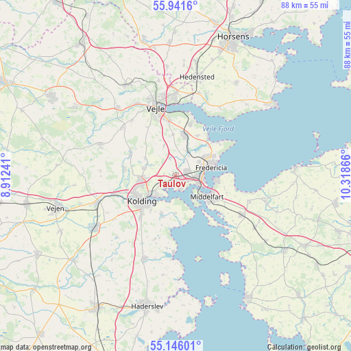
Taulov GPS coordinates[2]
55° 32' 44.952" North, 9° 36' 55.908" East
| Map corner | latitude | longitude |
|---|---|---|
| Upper-left | 55.9416°, | 8.91241° |
| Center: | 55.54582°, | 9.61553° |
| Lower-right: | 55.14601°, | 10.31866° |
| Map W x H: | 88.5×88.5 km | = 55×55mi |
| max Lat: | 57.72093° ⇑63.7% North |
| Taulov: | 55.54582° |
| min Lat: | ⇓36.3% South 54.57644° |
| min Long | Taulov | max Long |
| 8.12605° | 9.61553° | 15.18662° |
| W 24%⇐ | ⇒76% E |
Elevation
Elevation of Taulov is 30 m = 98 ft, and this is 2.7 m = 9 ft above average elevation for this country.
| Max E: |
114 m = 374 ft | 39.2% |
| Taulov | 30 m 98 ft | |
| Avg. | 27.3 m = 90 ft | |
Min E: |
0 m = 0 ft | 60.8% |
See also: Denmark elevation on elevation.city.
Geographical zone
Taulov is located in North temperate zone (between Tropic of Cancer and the Arctic Circle). Distance of this North polar circle is 1225.1 km =761.2 mi to North.| Distance of | km | miles | from Taulov |
|---|---|---|---|
| North Pole | 3830.9 | 2380.4 | to North |
| Arctic Circle | 1225.1 | 761.2 | to North |
| Tropic Cancer | 3570.2 | 2218.4 | to South |
| Equator | 6176.1 | 3837.6 | to South |


Nearby cities:
15 places around Taulov: (largest is in red/bold)
• Brejning
13.8 km =8.6 mi,  14°
14°
• Brenderup
23.9 km =14.9 mi,  106°
106°
• Børkop
10.9 km =6.8 mi, 11°
• Christiansfeld
22.4 km =13.9 mi,  201°
201°
• Egtved
20.9 km =13 mi,  291°
291°
• Ejby
23.6 km =14.7 mi,  123°
123°
• Fredericia
8.9 km =5.5 mi,  75°
75°
• Kolding
10.9 km =6.8 mi,  235°
235°
• Lunderskov
21.1 km =13.1 mi,  250°
250°
• Middelfart
8.5 km =5.3 mi, 121°
• Nørre Åby
19.1 km =11.9 mi, 119°
• Snoghøj
7.1 km =4.4 mi, 111°
• Strib
9.6 km =6 mi,  93°
93°
• Sønder Bjert
10.8 km =6.7 mi, 196°
• Vejle
18.9 km =11.7 mi,  344°
344°
Sources, notices
• [Note1] Compared only with cities in Denmark existing in our database
• [Src1] Map data: © OpenStreetMap contributors (CC-BY-SA)
• [Src2] Other city data from geonames.org with taken over terms of usage.
• [Src3] Geographical zone / Annual Mean Temperature by Robert A. Rohde @ Wikipedia
