Thisted geodata
Thisted (North Denmark) is a seat of a second-order administrative division; located in Denmark in Europe/Copenhagen (GMT+2) time zone. With population of 13,020 people, there are 60 cities with bigger population in this country. Compared to other cities in Denmark, 90.1% of cities are located further ↓South; 94.4% of cities are located further →East and 92.7% of cities have higher elevation than Thisted. Note1


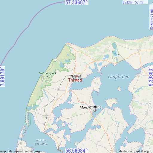
Thisted GPS coordinates[2]
56° 57' 18.828" North, 8° 41' 41.676" East
| Map corner | latitude | longitude |
|---|---|---|
| Upper-left | 57.33667°, | 7.99178° |
| Center: | 56.95523°, | 8.69491° |
| Lower-right: | 56.56984°, | 9.39803° |
| Map W x H: | 85.3×85.3 km | = 53×53mi |
| max Lat: | 57.72093° ⇑9.9% North |
| Thisted: | 56.95523° |
| min Lat: | ⇓90.1% South 54.57644° |
| min Long | Thisted | max Long |
| 8.12605° | 8.69491° | 15.18662° |
| W 5.6%⇐ | ⇒94.4% E |
Elevation
Elevation of Thisted is 4 m = 13 ft, and this is 23.3 m = 76 ft below average elevation for this country.
| Max E: |
114 m = 374 ft | 92.7% |
| Avg. | 27.3 m = 90 ft | |
| Thisted | 4 m = 13 ft | |
Min E: |
0 m = 0 ft | 7.3% |
See also: Denmark elevation on elevation.city.
Geographical zone
Thisted is located in North temperate zone (between Tropic of Cancer and the Arctic Circle). Distance of this North polar circle is 1068.3 km =663.8 mi to North.| Distance of | km | miles | from Thisted |
|---|---|---|---|
| North Pole | 3674.2 | 2283 | to North |
| Arctic Circle | 1068.3 | 663.8 | to North |
| Tropic Cancer | 3726.9 | 2315.8 | to South |
| Equator | 6332.8 | 3935 | to South |


Nearby cities:
15 places around Thisted: (largest is in red/bold)
• Aars
52.6 km =32.7 mi,  108°
108°
• Brovst
52.5 km =32.6 mi,  72°
72°
• Farsø
44.1 km =27.4 mi,  117°
117°
• Fjerritslev
37.6 km =23.4 mi, 66°
• Hanstholm
18.4 km =11.4 mi,  345°
345°
• Harboøre
48.9 km =30.4 mi,  219°
219°
• Hurup
28.4 km =17.6 mi, 216°
• Lemvig
50.9 km =31.6 mi,  207°
207°
• Løgstør
34.2 km =21.3 mi,  88°
88°
• Nykøbing Mors
20.4 km =12.7 mi,  151°
151°
• Skive
47.7 km =29.6 mi, 154°
• Struer
51.9 km =32.2 mi,  186°
186°
• Thyborøn
41 km =25.5 mi,  225°
225°
• Vinderup
52.9 km =32.9 mi,  174°
174°
• Ålestrup
56.6 km =35.2 mi, 120°
Sources, notices
• [Note1] Compared only with cities in Denmark existing in our database
• [Src1] Map data: © OpenStreetMap contributors (CC-BY-SA)
• [Src2] Other city data from geonames.org with taken over terms of usage.
• [Src3] Geographical zone / Annual Mean Temperature by Robert A. Rohde @ Wikipedia
