Hurup geodata
Hurup (North Denmark) is a populated place; located in Denmark in Europe/Copenhagen (GMT+2) time zone. With population of 2,769 people, there are 229 cities with bigger population in this country. Compared to other cities in Denmark, 88% of cities are located further ↓South; 97.7% of cities are located further →East and 76.9% of cities have lower elevation than Hurup. Note1


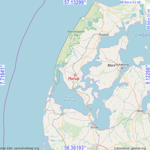
Hurup GPS coordinates[2]
56° 44' 57.984" North, 8° 25' 10.308" East
| Map corner | latitude | longitude |
|---|---|---|
| Upper-left | 57.13299°, | 7.71641° |
| Center: | 56.74944°, | 8.41953° |
| Lower-right: | 56.36193°, | 9.12266° |
| Map W x H: | 85.7×85.7 km | = 53.3×53.3mi |
| max Lat: | 57.72093° ⇑12% North |
| Hurup: | 56.74944° |
| min Lat: | ⇓88% South 54.57644° |
| min Long | Hurup | max Long |
| 8.12605° | 8.41953° | 15.18662° |
| W 2.3%⇐ | ⇒97.7% E |
Elevation
Elevation of Hurup is 43 m = 141 ft, and this is 15.7 m = 52 ft above average elevation for this country.
| Max E: |
114 m = 374 ft | 23.1% |
| Hurup | 43 m 141 ft | |
| Avg. | 27.3 m = 90 ft | |
Min E: |
0 m = 0 ft | 76.9% |
See also: Denmark elevation on elevation.city.
Geographical zone
Hurup is located in North temperate zone (between Tropic of Cancer and the Arctic Circle). Distance of this North polar circle is 1091.2 km =678 mi to North.| Distance of | km | miles | from Hurup |
|---|---|---|---|
| North Pole | 3697.1 | 2297.3 | to North |
| Arctic Circle | 1091.2 | 678 | to North |
| Tropic Cancer | 3704 | 2301.6 | to South |
| Equator | 6309.9 | 3920.8 | to South |


Nearby cities:
15 places around Hurup: (largest is in red/bold)
• Avlum
58.5 km =36.4 mi,  156°
156°
• Farsø
56.1 km =34.9 mi,  87°
87°
• Hanstholm
42.4 km =26.3 mi,  16°
16°
• Harboøre
20.7 km =12.9 mi,  224°
224°
• Holstebro
44.9 km =27.9 mi, 164°
• Lemvig
23.3 km =14.5 mi,  196°
196°
• Løgstør
56.2 km =34.9 mi,  65°
65°
• Nykøbing Mors
26.8 km =16.7 mi,  79°
79°
• Skive
42.3 km =26.3 mi,  118°
118°
• Stoholm
53.3 km =33.1 mi, 123°
• Struer
30.5 km =19 mi, 159°
• Thisted
28.4 km =17.6 mi,  36°
36°
• Thyborøn
13.9 km =8.6 mi,  245°
245°
• Ulfborg
53.9 km =33.5 mi,  186°
186°
• Vinderup
37 km =23 mi,  143°
143°
Sources, notices
• [Note1] Compared only with cities in Denmark existing in our database
• [Src1] Map data: © OpenStreetMap contributors (CC-BY-SA)
• [Src2] Other city data from geonames.org with taken over terms of usage.
• [Src3] Geographical zone / Annual Mean Temperature by Robert A. Rohde @ Wikipedia
