Løgstør geodata
Løgstør (North Denmark) is a populated place; located in Denmark in Europe/Copenhagen (GMT+2) time zone. With population of 4,469 people, there are 144 cities with bigger population in this country. Compared to other cities in Denmark, 90.4% of cities are located further ↓South; 84.5% of cities are located further →East and 50.9% of cities have higher elevation than Løgstør. Note1


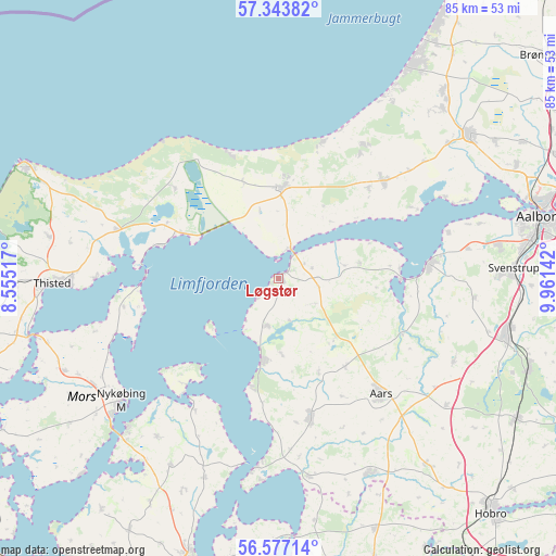
Løgstør GPS coordinates[2]
56° 57' 44.82" North, 9° 15' 29.88" East
| Map corner | latitude | longitude |
|---|---|---|
| Upper-left | 57.34382°, | 8.55517° |
| Center: | 56.96245°, | 9.2583° |
| Lower-right: | 56.57714°, | 9.96142° |
| Map W x H: | 85.2×85.2 km | = 52.9×52.9mi |
| max Lat: | 57.72093° ⇑9.6% North |
| Løgstør: | 56.96245° |
| min Lat: | ⇓90.4% South 54.57644° |
| min Long | Løgstør | max Long |
| 8.12605° | 9.2583° | 15.18662° |
| W 15.5%⇐ | ⇒84.5% E |
Elevation
Elevation of Løgstør is 21 m = 69 ft, and this is 6.3 m = 21 ft below average elevation for this country.
| Max E: |
114 m = 374 ft | 50.9% |
| Avg. | 27.3 m = 90 ft | |
| Løgstør | 21 m = 69 ft | |
Min E: |
0 m = 0 ft | 49.1% |
See also: Denmark elevation on elevation.city.
Geographical zone
Løgstør is located in North temperate zone (between Tropic of Cancer and the Arctic Circle). Distance of this North polar circle is 1067.5 km =663.3 mi to North.| Distance of | km | miles | from Løgstør |
|---|---|---|---|
| North Pole | 3673.4 | 2282.5 | to North |
| Arctic Circle | 1067.5 | 663.3 | to North |
| Tropic Cancer | 3727.7 | 2316.3 | to South |
| Equator | 6333.6 | 3935.5 | to South |


Nearby cities:
15 places around Løgstør: (largest is in red/bold)
• Aars
23.5 km =14.6 mi,  138°
138°
• Brovst
21.9 km =13.6 mi,  46°
46°
• Farsø
21.7 km =13.5 mi,  166°
166°
• Fjerritslev
14 km =8.7 mi,  1°
1°
• Frejlev
34.2 km =21.3 mi,  81°
81°
• Kås
36.2 km =22.5 mi,  43°
43°
• Nibe
23.2 km =14.4 mi, 84°
• Nykøbing Mors
31 km =19.3 mi,  232°
232°
• Pandrup
38.3 km =23.8 mi, 41°
• Støvring
36.2 km =22.5 mi,  103°
103°
• Svenstrup
35.8 km =22.2 mi,  88°
88°
• Thisted
34.2 km =21.3 mi,  268°
268°
• Vadum
40.1 km =24.9 mi,  64°
64°
• Åbybro
36.2 km =22.5 mi, 52°
• Ålestrup
33 km =20.5 mi,  154°
154°
Sources, notices
• [Note1] Compared only with cities in Denmark existing in our database
• [Src1] Map data: © OpenStreetMap contributors (CC-BY-SA)
• [Src2] Other city data from geonames.org with taken over terms of usage.
• [Src3] Geographical zone / Annual Mean Temperature by Robert A. Rohde @ Wikipedia
