Nykøbing Mors geodata
Nykøbing Mors (North Denmark) is a seat of a second-order administrative division; located in Denmark in Europe/Copenhagen (GMT+2) time zone. With population of 9,326 people, there are 80 cities with bigger population in this country. Compared to other cities in Denmark, 88.9% of cities are located further ↓South; 92.4% of cities are located further →East and 89.8% of cities have higher elevation than Nykøbing Mors. Note1


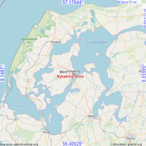
Nykøbing Mors GPS coordinates[2]
56° 47' 36.024" North, 8° 51' 10.152" East
| Map corner | latitude | longitude |
|---|---|---|
| Upper-left | 57.17644°, | 8.1497° |
| Center: | 56.79334°, | 8.85282° |
| Lower-right: | 56.40629°, | 9.55595° |
| Map W x H: | 85.6×85.6 km | = 53.2×53.2mi |
| max Lat: | 57.72093° ⇑11.1% North |
| Nykøbing Mors: | 56.79334° |
| min Lat: | ⇓88.9% South 54.57644° |
| min Long | Nykøbing Mors | max Long |
| 8.12605° | 8.85282° | 15.18662° |
| W 7.6%⇐ | ⇒92.4% E |
Elevation
Elevation of Nykøbing Mors is 5 m = 16 ft, and this is 22.3 m = 73 ft below average elevation for this country.
| Max E: |
114 m = 374 ft | 89.8% |
| Avg. | 27.3 m = 90 ft | |
| Nykøbing Mors | 5 m = 16 ft | |
Min E: |
0 m = 0 ft | 10.2% |
See also: Denmark elevation on elevation.city.
Geographical zone
Nykøbing Mors is located in North temperate zone (between Tropic of Cancer and the Arctic Circle). Distance of this North polar circle is 1086.3 km =675 mi to North.| Distance of | km | miles | from Nykøbing Mors |
|---|---|---|---|
| North Pole | 3692.2 | 2294.2 | to North |
| Arctic Circle | 1086.3 | 675 | to North |
| Tropic Cancer | 3708.9 | 2304.6 | to South |
| Equator | 6314.8 | 3923.8 | to South |


Nearby cities:
15 places around Nykøbing Mors: (largest is in red/bold)
• Aars
40.3 km =25 mi,  88°
88°
• Farsø
29.7 km =18.5 mi, 94°
• Fjerritslev
41.3 km =25.7 mi,  37°
37°
• Hanstholm
38.6 km =24 mi,  338°
338°
• Harboøre
45.4 km =28.2 mi,  244°
244°
• Hurup
26.8 km =16.7 mi,  259°
259°
• Lemvig
42.9 km =26.7 mi,  230°
230°
• Løgstør
31 km =19.3 mi,  52°
52°
• Skive
27.3 km =17 mi,  157°
157°
• Stoholm
38.7 km =24 mi,  152°
152°
• Struer
37.1 km =23.1 mi,  205°
205°
• Thisted
20.4 km =12.7 mi,  331°
331°
• Thyborøn
40.4 km =25.1 mi,  254°
254°
• Vinderup
34.9 km =21.7 mi,  187°
187°
• Ålestrup
40.6 km =25.2 mi,  105°
105°
Sources, notices
• [Note1] Compared only with cities in Denmark existing in our database
• [Src1] Map data: © OpenStreetMap contributors (CC-BY-SA)
• [Src2] Other city data from geonames.org with taken over terms of usage.
• [Src3] Geographical zone / Annual Mean Temperature by Robert A. Rohde @ Wikipedia
