Thyborøn geodata
Thyborøn (Central Jutland) is a populated place; located in Denmark in Europe/Copenhagen (GMT+2) time zone. With population of 2,587 people, there are 244 cities with bigger population in this country. Compared to other cities in Denmark, 87.4% of cities are located further ↓South; 99.4% of cities are located further →East and 98% of cities have higher elevation than Thyborøn. Note1


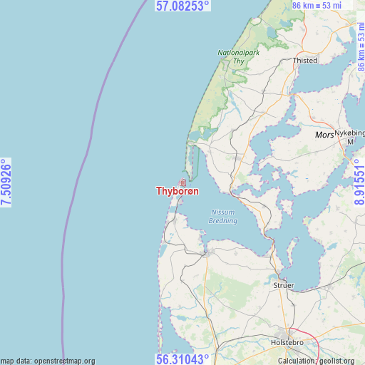
Thyborøn GPS coordinates[2]
56° 41' 54.456" North, 8° 12' 44.568" East
| Map corner | latitude | longitude |
|---|---|---|
| Upper-left | 57.08253°, | 7.50926° |
| Center: | 56.69846°, | 8.21238° |
| Lower-right: | 56.31043°, | 8.91551° |
| Map W x H: | 85.8×85.8 km | = 53.3×53.3mi |
| max Lat: | 57.72093° ⇑12.6% North |
| Thyborøn: | 56.69846° |
| min Lat: | ⇓87.4% South 54.57644° |
| min Long | Thyborøn | max Long |
| 8.12605° | 8.21238° | 15.18662° |
| W 0.6%⇐ | ⇒99.4% E |
Elevation
Elevation of Thyborøn is 2 m = 7 ft, and this is 25.3 m = 83 ft below average elevation for this country.
| Max E: |
114 m = 374 ft | 98% |
| Avg. | 27.3 m = 90 ft | |
| Thyborøn | 2 m = 7 ft | |
Min E: |
0 m = 0 ft | 2% |
See also: Denmark elevation on elevation.city.
Geographical zone
Thyborøn is located in North temperate zone (between Tropic of Cancer and the Arctic Circle). Distance of this North polar circle is 1096.9 km =681.6 mi to North.| Distance of | km | miles | from Thyborøn |
|---|---|---|---|
| North Pole | 3702.8 | 2300.8 | to North |
| Arctic Circle | 1096.9 | 681.6 | to North |
| Tropic Cancer | 3698.4 | 2298.1 | to South |
| Equator | 6304.3 | 3917.3 | to South |


Nearby cities:
15 places around Thyborøn: (largest is in red/bold)
• Avlum
59.9 km =37.2 mi,  143°
143°
• Hanstholm
52.5 km =32.6 mi,  27°
27°
• Harboøre
9.2 km =5.7 mi,  192°
192°
• Holstebro
45 km =28 mi,  146°
146°
• Hurup
13.9 km =8.6 mi,  65°
65°
• Lemvig
17.7 km =11 mi,  160°
160°
• Nykøbing Mors
40.4 km =25.1 mi, 74°
• Ringkøbing
67.7 km =42.1 mi,  178°
178°
• Skive
51.9 km =32.2 mi,  106°
106°
• Stoholm
61.9 km =38.5 mi, 112°
• Struer
32.7 km =20.3 mi,  134°
134°
• Thisted
41 km =25.5 mi,  45°
45°
• Ulfborg
48.4 km =30.1 mi,  172°
172°
• Vildbjerg
65.1 km =40.5 mi, 148°
• Vinderup
42.3 km =26.3 mi,  124°
124°
Sources, notices
• [Note1] Compared only with cities in Denmark existing in our database
• [Src1] Map data: © OpenStreetMap contributors (CC-BY-SA)
• [Src2] Other city data from geonames.org with taken over terms of usage.
• [Src3] Geographical zone / Annual Mean Temperature by Robert A. Rohde @ Wikipedia
