Svendborg geodata
Svendborg (South Denmark) is a seat of a second-order administrative division; located in Denmark in Europe/Copenhagen (GMT+2) time zone. With population of 27,553 people, there are 30 cities with bigger population in this country. Compared to other cities in Denmark, 89.8% of cities are located further ↑North; 59.1% of cities are located further ←West and 67% of cities have higher elevation than Svendborg. Note1


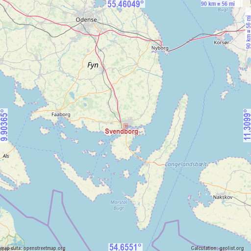
Svendborg GPS coordinates[2]
55° 3' 35.352" North, 10° 36' 24.372" East
| Map corner | latitude | longitude |
|---|---|---|
| Upper-left | 55.46049°, | 9.90365° |
| Center: | 55.05982°, | 10.60677° |
| Lower-right: | 54.6551°, | 11.3099° |
| Map W x H: | 89.6×89.5 km | = 55.7×55.6mi |
| max Lat: | 57.72093° ⇑89.8% North |
| Svendborg: | 55.05982° |
| min Lat: | ⇓10.2% South 54.57644° |
| min Long | Svendborg | max Long |
| 8.12605° | 10.60677° | 15.18662° |
| W 59.1%⇐ | ⇒40.9% E |
Elevation
Elevation of Svendborg is 14 m = 46 ft, and this is 13.3 m = 44 ft below average elevation for this country.
| Max E: |
114 m = 374 ft | 67% |
| Avg. | 27.3 m = 90 ft | |
| Svendborg | 14 m = 46 ft | |
Min E: |
0 m = 0 ft | 33% |
See also: Denmark elevation on elevation.city.
Geographical zone
Svendborg is located in North temperate zone (between Tropic of Cancer and the Arctic Circle). Distance of this North polar circle is 1279.1 km =794.8 mi to North.| Distance of | km | miles | from Svendborg |
|---|---|---|---|
| North Pole | 3885 | 2414 | to North |
| Arctic Circle | 1279.1 | 794.8 | to North |
| Tropic Cancer | 3516.2 | 2184.9 | to South |
| Equator | 6122.1 | 3804.1 | to South |


Nearby cities:
15 places around Svendborg: (largest is in red/bold)
• Bellinge
35.6 km =22.1 mi,  329°
329°
• Faaborg
23.5 km =14.6 mi,  279°
279°
• Højby
32.1 km =19.9 mi,  340°
340°
• Langeskov
33 km =20.5 mi,  357°
357°
• Marstal
23.3 km =14.5 mi,  194°
194°
• Neder Holluf
35.3 km =21.9 mi, 343°
• Nyborg
30.4 km =18.9 mi,  22°
22°
• Ringe
21.4 km =13.3 mi, 337°
• Rudkøbing
15.2 km =9.4 mi,  154°
154°
• Thurø By
3.9 km =2.4 mi,  110°
110°
• Ullerslev
33.7 km =20.9 mi,  4°
4°
• Vester-Skerninge
9.8 km =6.1 mi, 278°
• Vindeby
1.7 km =1.1 mi,  166°
166°
• Årslev
28.6 km =17.8 mi, 341°
• Ærøskøbing
22.8 km =14.2 mi,  213°
213°
Sources, notices
• [Note1] Compared only with cities in Denmark existing in our database
• [Src1] Map data: © OpenStreetMap contributors (CC-BY-SA)
• [Src2] Other city data from geonames.org with taken over terms of usage.
• [Src3] Geographical zone / Annual Mean Temperature by Robert A. Rohde @ Wikipedia
