Ringe geodata
Ringe (South Denmark) is a seat of a second-order administrative division; located in Denmark in Europe/Copenhagen (GMT+2) time zone. With population of 4,849 people, there are 135 cities with bigger population in this country. Compared to other cities in Denmark, 85.7% of cities are located further ↑North; 56.1% of cities are located further ←West and 97.1% of cities have lower elevation than Ringe. Note1


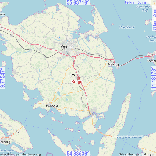
Ringe GPS coordinates[2]
55° 14' 17.808" North, 10° 28' 42.96" East
| Map corner | latitude | longitude |
|---|---|---|
| Upper-left | 55.63716°, | 9.77547° |
| Center: | 55.23828°, | 10.4786° |
| Lower-right: | 54.83536°, | 11.18173° |
| Map W x H: | 89.2×89.2 km | = 55.4×55.4mi |
| max Lat: | 57.72093° ⇑85.7% North |
| Ringe: | 55.23828° |
| min Lat: | ⇓14.3% South 54.57644° |
| min Long | Ringe | max Long |
| 8.12605° | 10.4786° | 15.18662° |
| W 56.1%⇐ | ⇒43.9% E |
Elevation
Elevation of Ringe is 75 m = 246 ft, and this is 47.7 m = 156 ft above average elevation for this country.
| Max E: |
114 m = 374 ft | 2.9% |
| Ringe | 75 m 246 ft | |
| Avg. | 27.3 m = 90 ft | |
Min E: |
0 m = 0 ft | 97.1% |
See also: Denmark elevation on elevation.city.
Geographical zone
Ringe is located in North temperate zone (between Tropic of Cancer and the Arctic Circle). Distance of this North polar circle is 1259.3 km =782.5 mi to North.| Distance of | km | miles | from Ringe |
|---|---|---|---|
| North Pole | 3865.1 | 2401.7 | to North |
| Arctic Circle | 1259.3 | 782.5 | to North |
| Tropic Cancer | 3536 | 2197.2 | to South |
| Equator | 6141.9 | 3816.4 | to South |


Nearby cities:
15 places around Ringe: (largest is in red/bold)
• Bellinge
14.7 km =9.1 mi,  317°
317°
• Bullerup
21 km =13 mi,  358°
358°
• Faaborg
21.9 km =13.6 mi,  223°
223°
• Hårby
22.6 km =14 mi,  265°
265°
• Højby
10.7 km =6.6 mi,  345°
345°
• Langeskov
14.8 km =9.2 mi,  27°
27°
• Neder Holluf
14.2 km =8.8 mi, 352°
• Nyborg
21.4 km =13.3 mi,  67°
67°
• Odense
18.4 km =11.4 mi,  341°
341°
• Seden
21 km =13 mi, 353°
• Svendborg
21.4 km =13.3 mi,  157°
157°
• Tommerup
19.5 km =12.1 mi,  297°
297°
• Ullerslev
17.6 km =10.9 mi,  38°
38°
• Vester-Skerninge
18.4 km =11.4 mi,  184°
184°
• Årslev
7.3 km =4.5 mi, 352°
Sources, notices
• [Note1] Compared only with cities in Denmark existing in our database
• [Src1] Map data: © OpenStreetMap contributors (CC-BY-SA)
• [Src2] Other city data from geonames.org with taken over terms of usage.
• [Src3] Geographical zone / Annual Mean Temperature by Robert A. Rohde @ Wikipedia
