Nyborg geodata
Nyborg (South Denmark) is a seat of a second-order administrative division; located in Denmark in Europe/Copenhagen (GMT+2) time zone. With population of 15,826 people, there are 47 cities with bigger population in this country. Compared to other cities in Denmark, 81.3% of cities are located further ↑North; 61.1% of cities are located further ←West and 84.5% of cities have higher elevation than Nyborg. Note1


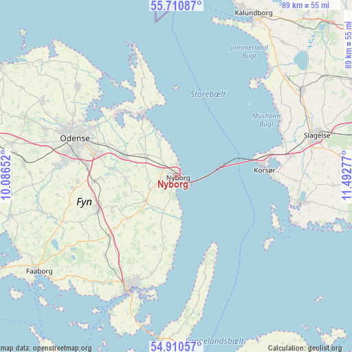
Nyborg GPS coordinates[2]
55° 18' 45.864" North, 10° 47' 22.704" East
| Map corner | latitude | longitude |
|---|---|---|
| Upper-left | 55.71087°, | 10.08652° |
| Center: | 55.31274°, | 10.78964° |
| Lower-right: | 54.91057°, | 11.49277° |
| Map W x H: | 89×89 km | = 55.3×55.3mi |
| max Lat: | 57.72093° ⇑81.3% North |
| Nyborg: | 55.31274° |
| min Lat: | ⇓18.7% South 54.57644° |
| min Long | Nyborg | max Long |
| 8.12605° | 10.78964° | 15.18662° |
| W 61.1%⇐ | ⇒38.9% E |
Elevation
Elevation of Nyborg is 7 m = 23 ft, and this is 20.3 m = 67 ft below average elevation for this country.
| Max E: |
114 m = 374 ft | 84.5% |
| Avg. | 27.3 m = 90 ft | |
| Nyborg | 7 m = 23 ft | |
Min E: |
0 m = 0 ft | 15.5% |
See also: Denmark elevation on elevation.city.
Geographical zone
Nyborg is located in North temperate zone (between Tropic of Cancer and the Arctic Circle). Distance of this North polar circle is 1251 km =777.3 mi to North.| Distance of | km | miles | from Nyborg |
|---|---|---|---|
| North Pole | 3856.9 | 2396.6 | to North |
| Arctic Circle | 1251 | 777.3 | to North |
| Tropic Cancer | 3544.3 | 2202.3 | to South |
| Equator | 6150.2 | 3821.6 | to South |


Nearby cities:
15 places around Nyborg: (largest is in red/bold)
• Bellinge
29.8 km =18.5 mi,  274°
274°
• Bullerup
23.8 km =14.8 mi,  302°
302°
• Højby
22.4 km =13.9 mi,  275°
275°
• Kerteminde
17.3 km =10.7 mi,  331°
331°
• Korsør
22.2 km =13.8 mi,  85°
85°
• Langeskov
13.9 km =8.6 mi,  290°
290°
• Munkebo
21.7 km =13.5 mi,  316°
316°
• Neder Holluf
22.3 km =13.9 mi, 284°
• Odense
27 km =16.8 mi, 290°
• Ringe
21.4 km =13.3 mi,  247°
247°
• Seden
25.3 km =15.7 mi, 299°
• Stige
27.8 km =17.3 mi, 300°
• Svendborg
30.4 km =18.9 mi,  202°
202°
• Ullerslev
10.3 km =6.4 mi, 302°
• Årslev
20.6 km =12.8 mi, 267°
Sources, notices
• [Note1] Compared only with cities in Denmark existing in our database
• [Src1] Map data: © OpenStreetMap contributors (CC-BY-SA)
• [Src2] Other city data from geonames.org with taken over terms of usage.
• [Src3] Geographical zone / Annual Mean Temperature by Robert A. Rohde @ Wikipedia
