Bellinge geodata
Bellinge (South Denmark) is a populated place; located in Denmark in Europe/Copenhagen (GMT+2) time zone. With population of 4,129 people, there are 155 cities with bigger population in this country. Compared to other cities in Denmark, 79.2% of cities are located further ↑North; 52.3% of cities are located further ←West and 57.3% of cities have lower elevation than Bellinge. Note1


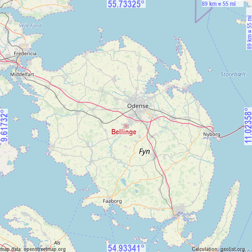
Bellinge GPS coordinates[2]
55° 20' 7.26" North, 10° 19' 13.62" East
| Map corner | latitude | longitude |
|---|---|---|
| Upper-left | 55.73325°, | 9.61732° |
| Center: | 55.33535°, | 10.32045° |
| Lower-right: | 54.93341°, | 11.02358° |
| Map W x H: | 88.9×88.9 km | = 55.2×55.2mi |
| max Lat: | 57.72093° ⇑79.2% North |
| Bellinge: | 55.33535° |
| min Lat: | ⇓20.8% South 54.57644° |
| min Long | Bellinge | max Long |
| 8.12605° | 10.32045° | 15.18662° |
| W 52.3%⇐ | ⇒47.7% E |
Elevation
Elevation of Bellinge is 27 m = 89 ft, and this is 0.3 m = 1 ft below average elevation for this country.
| Max E: |
114 m = 374 ft | 42.7% |
| Avg. | 27.3 m = 90 ft | |
| Bellinge | 27 m = 89 ft | |
Min E: |
0 m = 0 ft | 57.3% |
See also: Denmark elevation on elevation.city.
Geographical zone
Bellinge is located in North temperate zone (between Tropic of Cancer and the Arctic Circle). Distance of this North polar circle is 1248.5 km =775.8 mi to North.| Distance of | km | miles | from Bellinge |
|---|---|---|---|
| North Pole | 3854.3 | 2395 | to North |
| Arctic Circle | 1248.5 | 775.8 | to North |
| Tropic Cancer | 3546.8 | 2203.9 | to South |
| Equator | 6152.7 | 3823.1 | to South |


Nearby cities:
15 places around Bellinge: (largest is in red/bold)
• Bullerup
13.9 km =8.6 mi,  43°
43°
• Glamsbjerg
15.3 km =9.5 mi,  242°
242°
• Hårby
17.6 km =10.9 mi,  225°
225°
• Højby
7.4 km =4.6 mi,  93°
93°
• Langeskov
16.9 km =10.5 mi,  81°
81°
• Neder Holluf
8.7 km =5.4 mi,  68°
68°
• Odense
8 km =5 mi,  32°
32°
• Ringe
14.7 km =9.1 mi,  137°
137°
• Seden
12.7 km =7.9 mi, 37°
• Stige
12.9 km =8 mi, 25°
• Søndersø
17.2 km =10.7 mi,  346°
346°
• Tommerup
7.4 km =4.6 mi,  256°
256°
• Tommerup Stationsby
9.2 km =5.7 mi,  276°
276°
• Vissenbjerg
12.8 km =8 mi,  295°
295°
• Årslev
9.8 km =6.1 mi,  111°
111°
Sources, notices
• [Note1] Compared only with cities in Denmark existing in our database
• [Src1] Map data: © OpenStreetMap contributors (CC-BY-SA)
• [Src2] Other city data from geonames.org with taken over terms of usage.
• [Src3] Geographical zone / Annual Mean Temperature by Robert A. Rohde @ Wikipedia
