Ullerslev geodata
Ullerslev (South Denmark) is a populated place; located in Denmark in Europe/Copenhagen (GMT+2) time zone. With population of 2,962 people, there are 215 cities with bigger population in this country. Compared to other cities in Denmark, 77.8% of cities are located further ↑North; 59.6% of cities are located further ←West and 67% of cities have higher elevation than Ullerslev. Note1


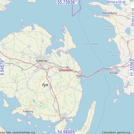
Ullerslev GPS coordinates[2]
55° 21' 42.192" North, 10° 39' 6.84" East
| Map corner | latitude | longitude |
|---|---|---|
| Upper-left | 55.75936°, | 9.94878° |
| Center: | 55.36172°, | 10.6519° |
| Lower-right: | 54.96005°, | 11.35503° |
| Map W x H: | 88.9×88.9 km | = 55.2×55.2mi |
| max Lat: | 57.72093° ⇑77.8% North |
| Ullerslev: | 55.36172° |
| min Lat: | ⇓22.2% South 54.57644° |
| min Long | Ullerslev | max Long |
| 8.12605° | 10.6519° | 15.18662° |
| W 59.6%⇐ | ⇒40.4% E |
Elevation
Elevation of Ullerslev is 14 m = 46 ft, and this is 13.3 m = 44 ft below average elevation for this country.
| Max E: |
114 m = 374 ft | 67% |
| Avg. | 27.3 m = 90 ft | |
| Ullerslev | 14 m = 46 ft | |
Min E: |
0 m = 0 ft | 33% |
See also: Denmark elevation on elevation.city.
Geographical zone
Ullerslev is located in North temperate zone (between Tropic of Cancer and the Arctic Circle). Distance of this North polar circle is 1245.5 km =773.9 mi to North.| Distance of | km | miles | from Ullerslev |
|---|---|---|---|
| North Pole | 3851.4 | 2393.1 | to North |
| Arctic Circle | 1245.5 | 773.9 | to North |
| Tropic Cancer | 3549.7 | 2205.7 | to South |
| Equator | 6155.6 | 3824.9 | to South |


Nearby cities:
15 places around Ullerslev: (largest is in red/bold)
• Bellinge
21.2 km =13.2 mi,  262°
262°
• Bullerup
13.5 km =8.4 mi,  302°
302°
• Højby
14 km =8.7 mi, 256°
• Kerteminde
9.7 km =6 mi,  2°
2°
• Langeskov
4.3 km =2.7 mi, 262°
• Munkebo
12.1 km =7.5 mi,  329°
329°
• Neder Holluf
12.9 km =8 mi,  271°
271°
• Nyborg
10.3 km =6.4 mi,  122°
122°
• Odense
17.1 km =10.6 mi,  282°
282°
• Otterup
23.4 km =14.5 mi,  316°
316°
• Ringe
17.6 km =10.9 mi,  218°
218°
• Seden
15 km =9.3 mi, 298°
• Stige
17.6 km =10.9 mi, 299°
• Tommerup
28.5 km =17.7 mi, 260°
• Årslev
13.5 km =8.4 mi,  241°
241°
Sources, notices
• [Note1] Compared only with cities in Denmark existing in our database
• [Src1] Map data: © OpenStreetMap contributors (CC-BY-SA)
• [Src2] Other city data from geonames.org with taken over terms of usage.
• [Src3] Geographical zone / Annual Mean Temperature by Robert A. Rohde @ Wikipedia
